The England Coast Path, or, to give it it’s full name, the King Charles III England Coast Path, is the longest managed coastal trail in the world. It totals around 2700 miles (4350km) and includes an extremely varied history, natural history, terrain and geology.
I completed the 630 mile South West Coast Path (a National Trail) back in 2018 as part of a longer hike across the UK. Even then I was considering the possibility of tackling the entire England Coast. I have slowly been knocking off sections but am continually distracted by other trails, not least the neighbouring 870 mile (1400km) Wales Coast Path. That is another coastal trail that I am steadily completing in stages.
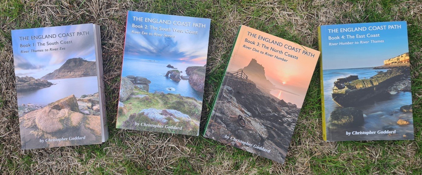
This page is an evolving attempt at recording my progress on the England Coast Path. Sections included below are those I have completed. For this I am using the sections, stages, distances and ascent as recorded in the excellent four volume set of guidebooks written by Christopher Goddard. These books cover the entire trail, including those few sections not yet formally opened. His stages are seldom as I walked them at the time. Some of my stages may have started or ended at different locations, or were even walked in the opposite direction.
| Section | Stage | Distance (miles) | Distance (km) | Ascent |
| North Kent Coast | Complete | |||
| 1.1 | Woolwich to Dartford | 13 | 20.6 | 60m |
| 1.2 | Dartford to Gravesend | 11.5 | 18.7 | 80m |
| 1.3 | Gravesend to Allhallows-on-Sea | 17.5 | 28.5 | 30m |
| 1.4 | Allhallows-on-Sea to Hoo St Werburgh | 15.5 | 24.8 | 60m |
| 1.5 | Hoo St Werburgh to Gillingham | 11.5 | 18.4 | 80m |
| 1.6 | Gillingham to Swale | 15.5 | 25 | 90m |
| 1.7 | Swale to Leysdown-on-Sea | 17 | 27.3 | 200m |
| 1.8 | Leysdown-on-Sea to Swale | 16.5 | 26.7 | 40m |
| 1.9 | Swale to Faversham | 18 | 29 | 30m |
| 1.10 | Faversham to Herne Bay | 14 | 22.5 | 20m |
| 1.11 | Herne Bay to Margate | 12 | 19.5 | 100m |
| South Kent Coast | Complete | |||
| 2.1 | Margate to Sandwich | 15.5 | 24.8 | 220m |
| 2.2 | Sandwich to Deal | 10.5 | 16.6 | 20m |
| 2.3 | Deal to Dover | 10 | 15.6 | 390m |
| 2.4 | Dover to Hythe | 13.5 | 21.3 | 550m |
| 2.5 | Hythe to Lydd-on-Sea | 12.5 | 20 | 10m |
| 2.6 | Lydd-on-Sea to Rye | 16 | 25.4 | 20m |
| The Sussex Coast | incomplete | |||
| 3.1 | Rye to Hastings | 14 | 22.9 | 440m |
| The Hampshire Coast | Not done | |||
| The Isle of Wight | Complete | |||
| 5.1 | East Cowes to Bembridge | 14 | 22.6 | 250m |
| 5.2 | Bembridge to Ventnor | 12 | 19.5 | 350m |
| 5.3 | Ventnor to Brighstone | 15.5 | 24.8 | 560m |
| 5.4 | Brighstone to Totland | 12 | 19.3 | 450m |
| 5.5 | Totland to Shalfleet | 12 | 18.8 | 170m |
| 5.6 | Shalfleet to Cowes | 11 | 17.9 | 180m |
| 5.7 | Cowes to East Cowes | 9.5 | 15.3 | 100m |
| The Dorset and East Devon Coast | incomplete | |||
| 6.2 (only the South West Coast Path section) from Poole completed) | Bournemouth to Swanage (via Poole) | |||
| 6.3 | Swanage to coast near Worth Matravers | 10.5 | 16.2 | 500m |
| 6.4 | Coast near Worth Matravers to West Lulworth (via military ranges) | 10.5 | 17 | 550m |
| 6.5 | West Lulworth to Weymouth | 11.5 | 18.6 | 480m |
| 6.6 | Weymouth to Chiswell | 14.5 | 23.2 | 450m |
| 6.7 | Chiswell to Abbotsbury | 13 | 20.9 | 200m |
| 6.8 | Abbotsbury to Seatown | 12 | 19.2 | 290m |
| 6.9 | Seatown to Seaton | 14.5 | 23.3 | 930m |
| 6.10 | Seaton to Sidmouth | 10 | 15.6 | 770m |
| 6.11 | Sidmouth to Exmouth (where ferry to Starcross) | 13 | 20.5 | 480m |
| The South Devon Coast | Complete | |||
| 7.2 | Starcross to St Marychurch | 13 | 21 | 740m |
| 7.3 | Marychurch to Brixham | 13.5 | 21.8 | 560m |
| 7.4 | Brixham to Dartmouth | 10.5 | 16.9 | 830m |
| 7.5 | Dartmouth to Torcross | 10 | 16.1 | 510m |
| 7.6 | Torcross to Salcombe | 12.5 | 20 | 740m |
| 7.7 | Salcombe to Bigbury-on-Sea | 13 | 20.6 | 660m |
| 7.8 | Bigbury-on-Sea to Noss Mayo | 13.5 | 21.5 | 680m |
| 7.10 | Noss Mayo to Plymouth | 9 | 14.1 | 350m |
| The South Cornwall Coast | Complete | |||
| 8.1 | Plymouth to Portwrinkle | 15 | 24.2 | 730m |
| 8.2 | Portwrinkle to Looe | 8 | 13 | 490m |
| 8.3 | Looe to Fowey | 12 | 19.3 | 720m |
| 8.4 | Fowey to Mevagissey | 17.5 | 28.1 | 1010m |
| 8.5 | Mevagissey to Portloe | 12 | 19.6 | 720m |
| 8.6 | Portloe to Falmouth | 13.5 | 21.9 | 590m |
| 8.7 | Falmouth to Helford Passage | 10 | 16.1 | 350m |
| 8.8 | Helford to Coverack | 13 | 21.2 | 550m |
| 8.9 | Coverack to Lizard | 10 | 16.4 | 620 |
| The West Cornwall Coast | Complete | |||
| 9.1 | Lizard to Porthleven | 13.5 | 22 | 720m |
| 9.2 | Porthleven to Penzance | 13.5 | 21.9 | 580m |
| 9.3 | Penzance to Porthcurno | 11.5 | 18.4 | 610 |
| 9.4 | Porthcurno to St. Just | 12 | 19.2 | 650m |
| 9.5 | St. Just to Zennor | 10 | 16.2 | 660m |
| 9.6 | Zennor to Hayle | 13 | 20.6 | 600m |
| 9.7 | Hayle to Portreath | 12 | 19.3 | 410m |
| 9.8 | Portreath to Perranporth | 12 | 19.2 | 740m |
| 9.9 | Perranporth to Newquay (via tidal bridge across Gannel estuary) | 14 | 22.3 | 470m |
| The North Cornwall Coast | Complete | |||
| 10.1 | Newquay to Treyarnon | 12.5 | 20 | 470m |
| 10.2 | Treyarnon to Padstow/Rock | 11.5 | 18.3 | 330m |
| 10.3 | Rock to Port Isacc | 12 | 19 | 690m |
| 10.4 | Port Isaac to Boscastle | 14 | 22.4 | 1030m |
| 10.5 | Boscastle to Bude | 17 | 27.1 | 1330m |
| 10.6 | Bude to Hartland Quay | 15 | 24 | 1220m |
| The North Devon Coast | Complete | |||
| 11.1 | Hartland Quay to Clovelly | 12.5 | 20 | 680m |
| 11.2 | Clovelly to Westward Ho! | 11 | 17.9 | 600m |
| 11.3 | Westward Ho! to Instow | 11 | 17.7 | 50m |
| 11.4 | Instow to Braunton | 13 | 20.6 | 30m |
| 11.5 | Braunton to Woolacombe | 14.5 | 23.1 | 240m |
| 11.6 | Woolacombe to Combe Martin | 14 | 22.3 | 1000m |
| 11.7 | Combe Martin to Lynmouth | 13.5 | 22 | 950m |
| 11.8 | Lynmouth to Porlock Weir | 11.5 | 18.8 | 840m |
| The Somerset & Avon Coast | incomplete | |||
| 12.1 | Porlock Weir to Minehead | 9 | 14.8 | 350m |
| The Merseyside Coast | Not done | |||
| The Lancashire Coast | Not done | |||
| The South Cumbria Coast | Not done | |||
| The West Cumbria Coast | Not done | |||
| The Northumberland Coast | Complete | |||
| 17.1 | Scottish Border to Berwick-upon-Tweed | 5 | 8 | 170m |
| 17.2 | Berwick-upon-Tweed to Holy Island | 16 | 25 | 90m |
| 17.3 | Holy Island to Bamburgh | 17.5 | 28.4 | 120m |
| 17.4 | Bamburgh to Craster | 14 | 22.5 | 220m |
| 17.5 | Craster to Amble | 14.5 | 23.7 | 240m |
| 17.6 | Amble to Lynemouth | 11.5 | 18.6 | 60m |
| 17.7 | Lynemouth to Blyth | 12.5 | 20.1 | 110m |
| 17.8 | Blyth to North Shields | 12 | 18.9 | 120m |
| The Durham Coast | incomplete | |||
| 18.1 | South Shields to Sunderland | 11 | 17.8 | 180m |
| The North Yorkshire Coast | incomplete | |||
| 19.2 | Saltburn-by-the-Sea to Staithes | 8.5 | 14 | 390m |
| 19.3 | Staithes to Whitby | 11.5 | 18.8 | 560m |
| 19.4 | Whitby to Ravenscar | 10.5 | 16.8 | 720m |
| 19.5 | Ravenscar to Scarborough | 12 | 19.1 | 450m |
| 19.6 | Scarborough to Reighton Gap (incomplete section: have only walked as far as Filey) | 13.5 (prob only 9.5miles completed of this section) | 21.5 | 570m |
| The East Yorkshire Coast | Not done | |||
| The Lincolnshire Coast | Not done | |||
| The Norfolk Coast | incomplete | |||
| 22.2 | Heacham to Brancaster Staithe- Have only completed Hunstanton to Brancaster Staithe part of this section (Norfolk Coast Path) | 14.5 (12.5m completed) | 23.1 (19.5km completed) | 50m |
| 22.3 | Brancaster Staithe to Stiffkey | 14 | 22.3 | 40m |
| 22.4 | Stiffkey to Sheringham | 15 | 24.2 | 90m |
| 22.5 | Sheringham to Mundesley | 11.5 | 18.8 | 130m |
| The Suffolk Coast | Not done | |||
| The North Essex Coast | Not done | |||
| The South Essex Coast | Not done | |||
| Total mileage completed to date: 1166.5 as of September 2026 | ||||

