Morris’s Patent Chartometer
This months map measure is a wonderful chunky, clunky piece of Victorian engineering invented by Englishman Edward Russell Morris, of the Morris Patents Engineering Works, High Street, Birmingham. It dates from the 1870s and is capable of measuring a wide range of scales due to interchangeable card discs.
“The only instrument that measures and registers distances on maps, plans, scaled drawings etc, and that is adapted for various scales. By guiding the small steel wheel along any route on a map, the hand registers the actual distance in miles, yards etc, according to the dial in use and the scale of the map, which should correspond. To deal with a map of a different scale, the glass front is opened by pressing a spring; the dial removed, and another corresponding to the fresh scale slipped into its place. A set of dials adapted to the scales of all Ordnance maps, and the usual scales of travelling maps etc, is contained in a recess of the leather case, beneath the instrument.”
E. R. Morris

Back of Chartometer
The earliest versions of ‘Patent Chartometer’ were patented by Morris in 1873. He produced two versions of this large measure. A simpler device with rotating pointer, and the one shown here, with rotating pointer and totaliser.
The totaliser counts the number of revolutions of the pointer. Small red painted figures, counting from 1 – 10, can be seen through a small window to the right of the rotating pointer.
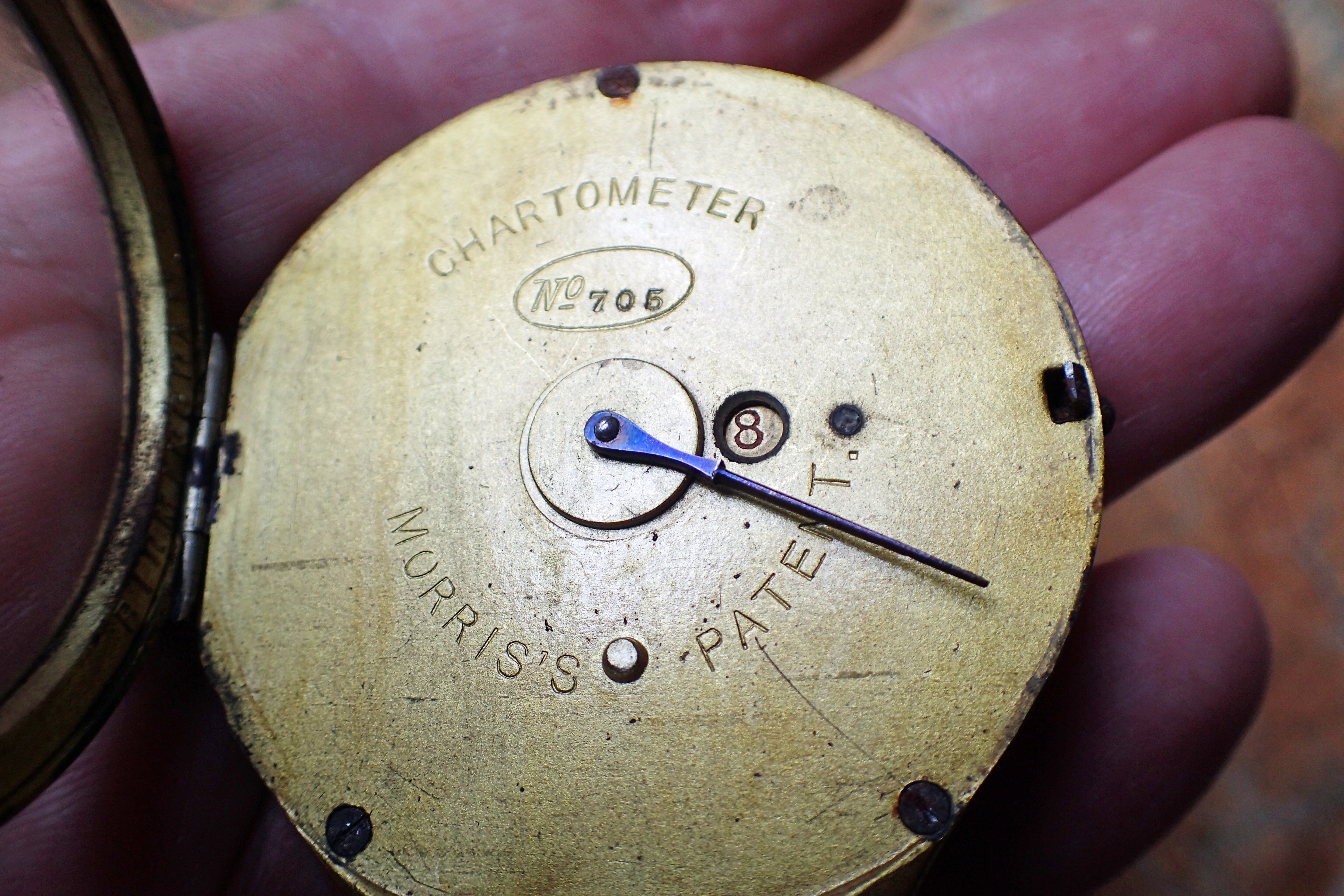
Face of Chartometer without scale card inserted. Revolution counter can be seen to the right of the pointer axis. The lower stud protrusion, between the words Morris’s and Patent, ensures an inserted card is correctly orientated
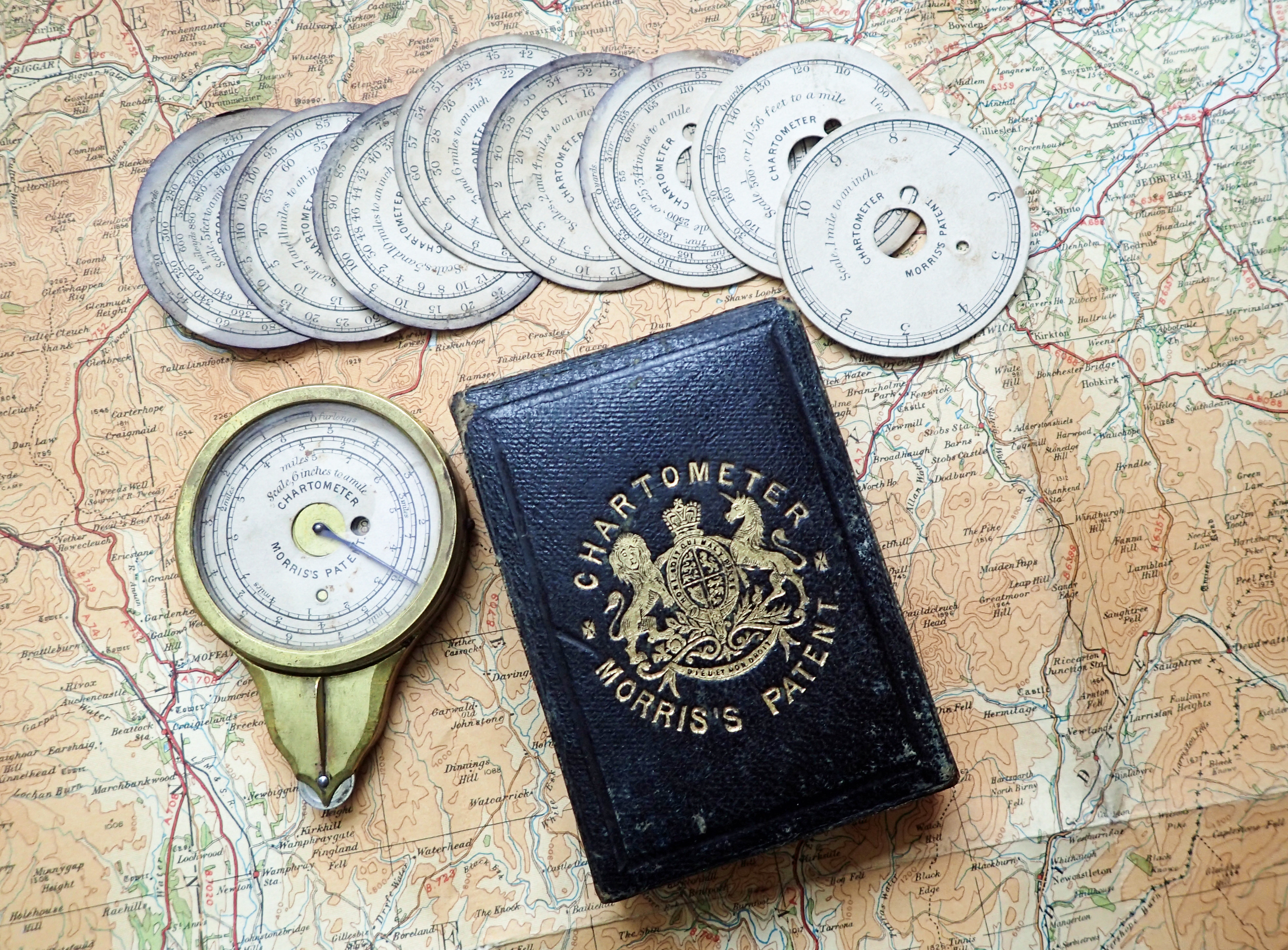
Morris’s Patent Chartometer and scale cards with leather bound wooden case
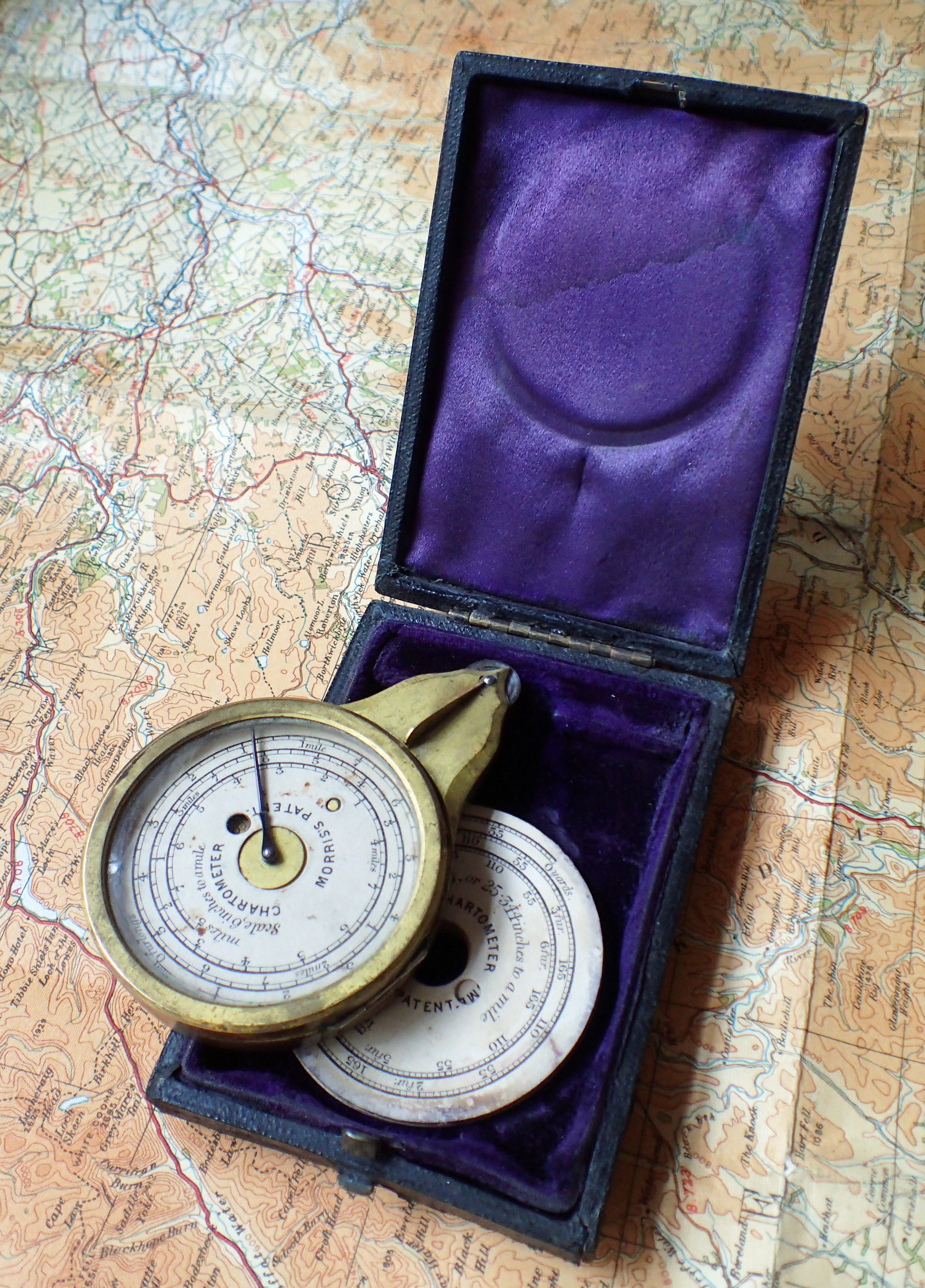
The map measurer shown here is serial number 705 and came supplied in a leather bound wooden case, with silk interior. Scale cards are stored below the measure in the case.
The map measure, or Chartometer, has a hinged glass front opened by a press button catch on the side of the brass case. With the desired scale card inserted and hinged front closed, the measure is held in the hand and the steel wheel at the bottom trundled along the line of whatever requires measuring, be that road, path or anything else. The measurement is then read off against the scale card and any total revolutions of the hand, as indicated by the totaliser, accounted for.
Morris was a member of the Institute of Civil Engineers from 1880 and designed and manufactured map measurers in a range of sizes, this is possibly the largest he produced. A bijou map measure also constructed by Morris was shown here recently. That weighed just 15g, the larger Chartometer shown here still only weighs 80g. The measure is 3 1/8″ tall, or 80mm in new money.
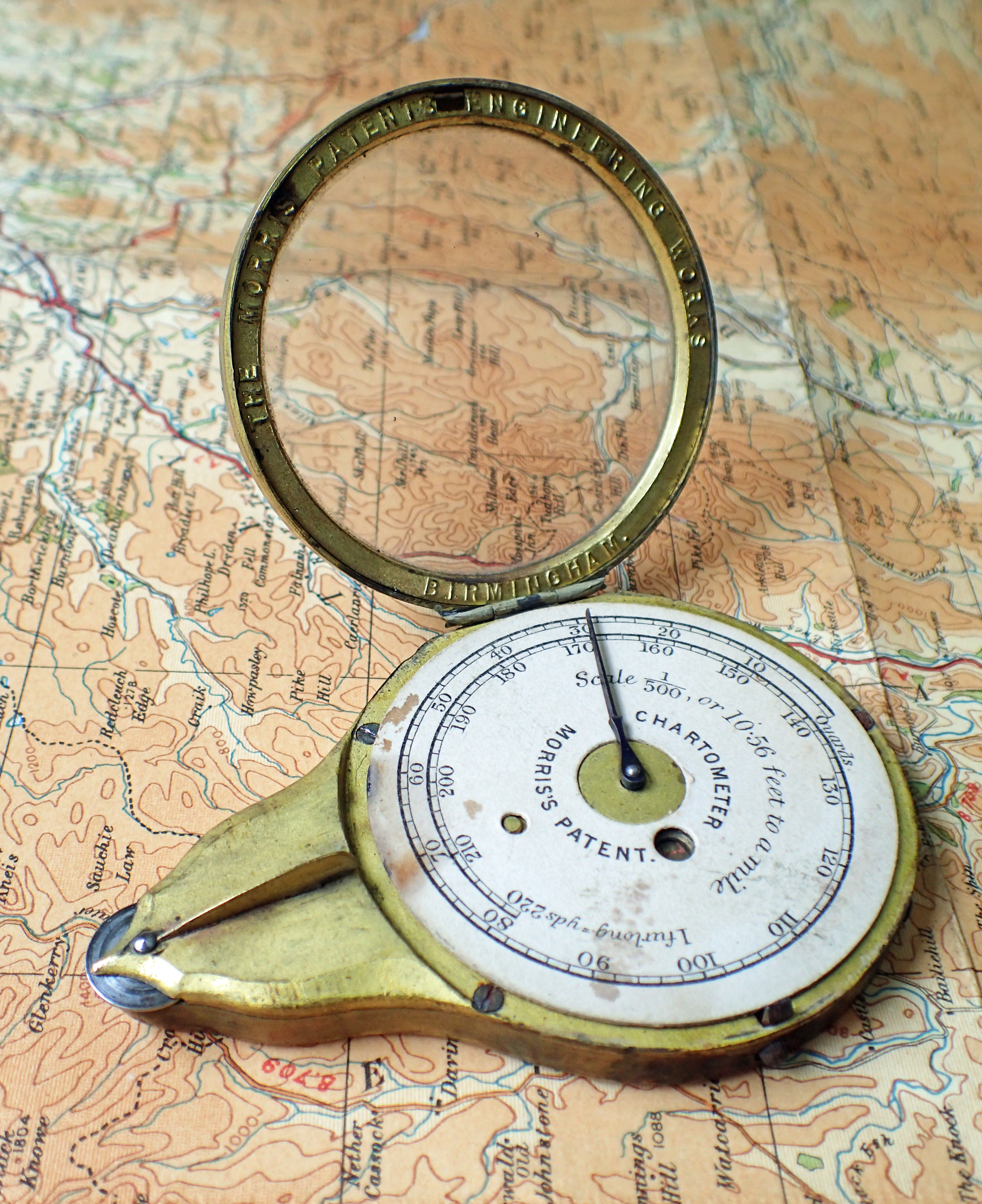
Morris’s Patent Chartometer. Cast into the underside of the hinged front is- “THE MORRIS PATENTS ENGINEERING WORKS BIRMINGHAM”
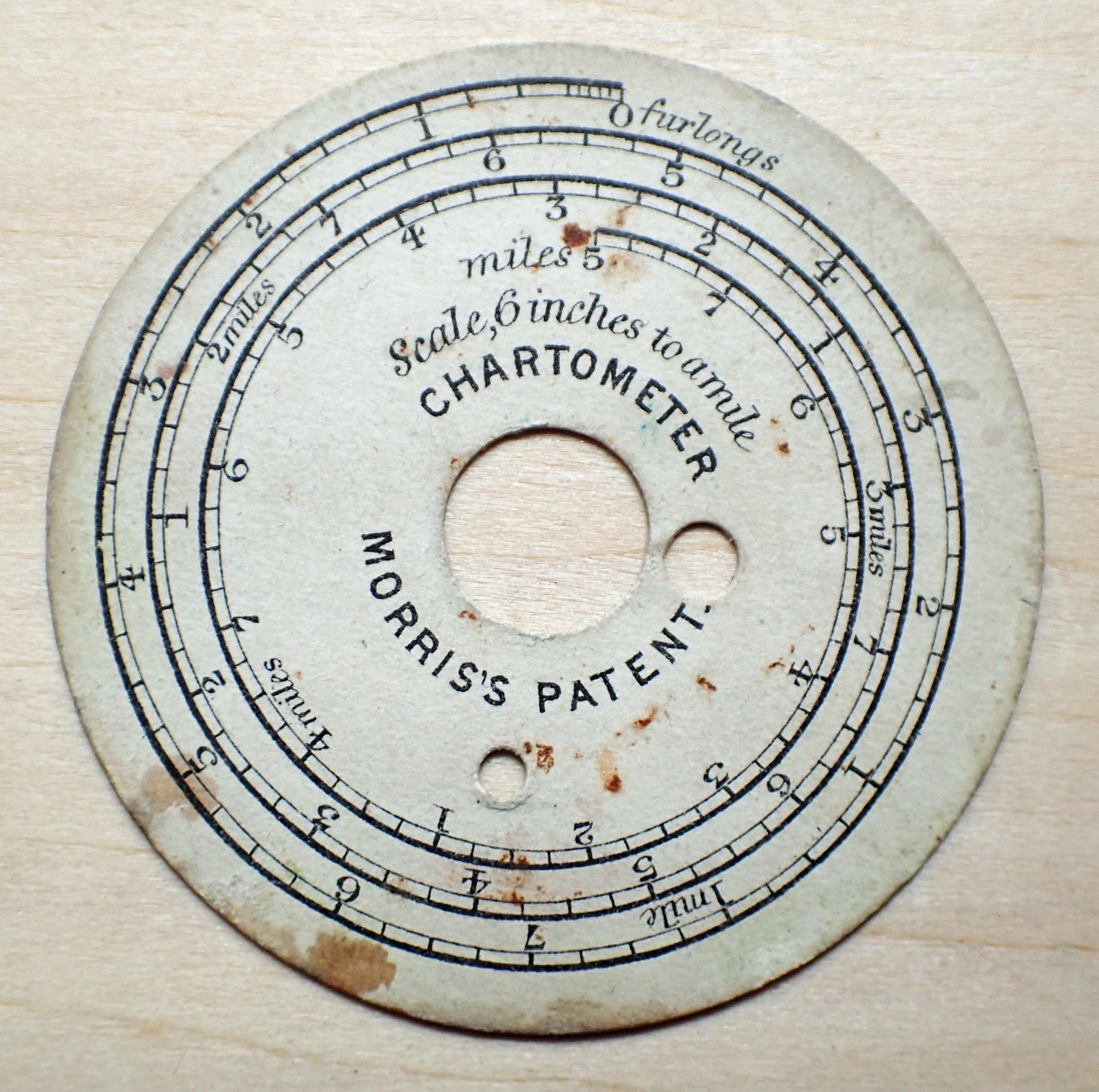
6 inch to the mile scale card measures furlongs. Five turns of the dial will indicate 40 furlongs, or five miles. Dials are 2″ / 50mm diameter
Nine cards, giving 13 direct scales, are supplied with the measure. These are:
- Scale 1/2500, or 25.344 inches to a mile
- Scale, 6 inches to a mile
- Scale 1/500, or 10.56 feet to a mile
- Scale, 1 mile to an inch
- Scales, 2 and 4 miles to an inch
- Scales, 3 and 6 miles to an inch
- Scales, 5 and 10 miles to an inch
- Scales, 7 and 11 miles to an inch
- Scale, 5 feet to a mile

Scale cards for Morris’s Patent Chartometer

Morris’s Patent Chartometer
The word ‘chartometer’ was described in Scientific Instruments 1500 – 1900 An Introduction, by Gerard L’Estrange Turner, with Andrew Turner (first published in 1980 as ‘Antique Scientific Instruments‘) thus:
“The opisometer is a small device for measuring the lengths of roads, rivers, walls etc., on maps. It is a milled wheel on a screw thread with a handle. The wheel traces the route, and is then wound backwards on the scale at the edge of the map. The chartometer is the same but has a dial and pointer to give the measure immediately.”
An example of an opisometer from the mid-nineteenth century was shown here earlier and it is clear what a step forward Morris’s Chartometer was for those measuring lines and routes.
Three Points of the Compass has looked at a few more Map Measurers in detail. Links to these can be found here.
