While many have made the change to exclusive use of digital mapping, Three Points of the Compass is often still using paper maps backed up by digital maps on the phone when on trail. Before I even leave home, there will be annotations on my paper map- phone numbers, arrows, circles, ‘tent’ symbols and drawings. These are invariably added to on trail. Anathema to some, but maps are a tool to be used and abused.

Go on, how many of you threw your hands up in horror at the very suggestion of writing or drawing on a paper map? Perhaps if it were a closeted example, to be kept on the shelf at home and pulled out for consultation only, then I could agree with that opinion. Too many people are loathe to contemplate the notion of marking a map in any manner. Receiving a spanking new map is a thrill- shiny, pristine, un-used, no creases, the prospect of adventure. But accept that a map is simply a guide and assistant to that adventure, don’t be afraid of using it so and annotating thus.
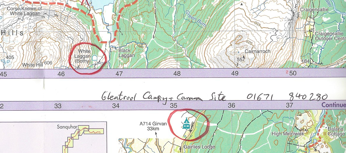
Paper maps in the field are a tool to be used. Remove the cover if it has one, fold it to suit the dimensions of whatever you keep it in, and make note of places to see or halt, where wild-camping might be possible, alternative ‘foul-weather’ route or escape routes, or where not to go. Mark it with where there might be food or water to look for, something of interest to see or sketch, a page reference in a guide book, where someone has said a phone signal might be obtained. Circle the location of campsites, hostels, bunkhouse and bothy. Even scribble in the margins the phone numbers for a proposed location. There is no need to overdo it otherwise a map becomes illegible, just include those notes of particular importance.
Pencils:
A ‘lead’ pencil doesn’t show up well on a map and can smudge but a 2B standard pencil is better than nothing. Propelling pencils poke holes in the paper. I have written before on various coloured pencils when I was suggesting choices for a lightweight art kit for use on trail, but none of those are fantastically suited to marking a map, particularly pastels, that can smear badly.
Standard coloured pencils are not especially suited for use with maps, especially waterproof maps. A Chinagraph pencil is required. Sometimes called a Grease Pencil, or wax marker, these pencils have a hardened coloured wax and are suited for writing on glossy non-porous surfaces such as maps, even porcelain or china, which is where the name Chinagraph stems from.
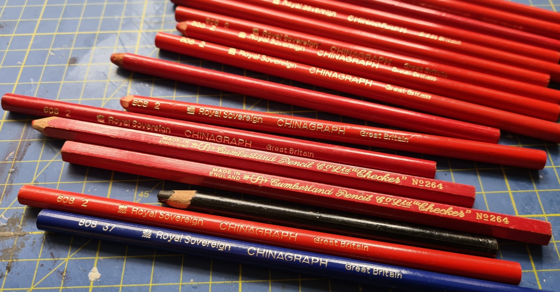
Back in my Royal Engineer days, the standard map pencil was the British Army blue Chinagraph used for marking maps with the location of minefields etc., however I have never felt blue the best colour for use with maps. I had a stock of vintage Cumberland Pencil Co. and Royal Sovereign Chinagraph pencils for years, decades even, but I made the switch to something still in production with a wider range of colours.
The maker of my favoured old pencil, the Royal Sovereign Pencil Company, entered into partnership with Staedtler in the early 1960s, eventually becoming a joint venture with them in 1966 but retained 51% until 1972 when they reduced holdings to 49%. The Royal Sovereign name is now separately owned and their Indonesian-made pencils are still available under a rebrand but in less colours and more importantly, are lower quality and a bit gritty, also highly resistant to water rather than permanent. It is the Staedtler product that I am using now, who knows, it may actually be closely related to my old favourite?
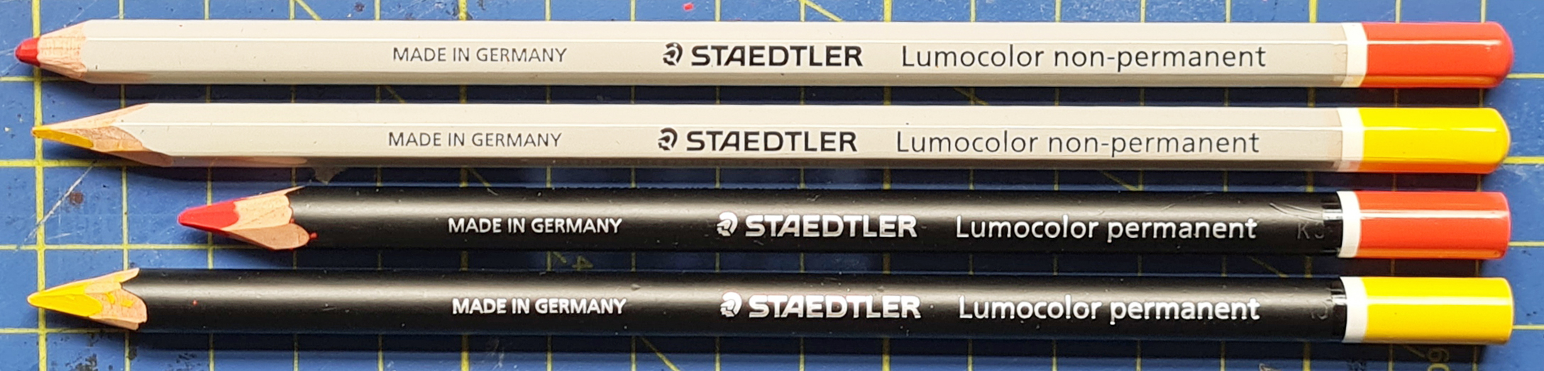
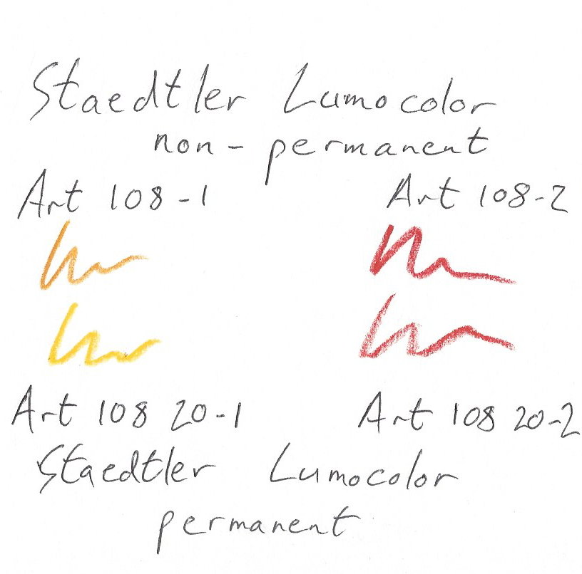
The pencils I have been using for the past few years are Staedtler Lumocolor Omnichrom Non-Permanent Pencil (yellow ART 108-1 and red ART 108-2) and Staedtler Lumocolor Glasochrom Permanent Pencil (yellow ART 108 20-1 and red ART 108 20-2). These will write on just about anything and each are available in a small range of colours. Non-waterproof can be rubbed out if necessary but permanent are more practical as markings resist inclement weather and abrasion better. They work on laminated maps, standard paper Ordnance Survey and other paper maps whether they are wet or dry. They do smear a little on Harvey waterproof maps but I persist in using them. These pencils are not difficult to source online but Shaven Raspberry are good for a one-stop shop for three colours. They suggest their own colour scheme, which is different to what I do, but hey, it is your map, mark it how you like. Not that it should become an issue, but these are also UV resistant.
Fun fact- In the 1964 film Goldfinger. James Bond uses one of Auric Goldfinger’s Royal Sovereign Chinagraph pencils to write a message to the CIA about the ‘Grand Slam’ operation
I use yellow and red pencils and will also use these for bullet-pointing something of importance in my trail journal, though not for note-taking itself as they are too soft and wear too quickly. I don’t carry one of these pencils on trail, though I could if I wished as a full size pencil only weighs 5.4g and half a pencil half that. They are easily sharpened with a knife. Do note however, that using these is no hard and fast rule, while actually ‘in the field’, I have scribbled and written and drawn on my maps with whatever was to hand.
Pens:
If you are going to use a pen as well as, or instead of, a chinagraph pencil, look for a fine point technical pen with permanent ink. These are easily available in different colours though a dark blue, dark brown or black is easiest to read in poor light conditions. Never use a sharpie, even the fine tips will obscure too much other detail on a map. I very often will also track a planned route in advance of a day walk with a highlighter. Pink or yellow lines are used most frequently and I used to include a tiny little highlighter in my ditty bag. These were 30mm long, and weighed 2g each but the stationers that supplied them went out of business and I have never found anything as small and light since.
Despite preferring a fountain pen for Pen and Wash I have also used a wide range of fine point technical pens for this, so have had plenty of opportunity to use different ones for writing on maps. To be honest, there has been little to choose between the better quality offerings. Probably the one I turn to most frequently is a 9g 0.1 Sakura Pigma Micron (0.25mm line), after this, the 0.1 Mitsubishi Uni Pin Fine Line, Staedtler Permanent Fine Point Lumocolor or 0.1 Staedtler Pigment Liner.

There are other ways of annotating a map. You could use removable transparent tape and write on that with a permanent marker, or use laminated maps and erase any temporary markings from these afterward with an alcohol pad from the First Aid Kit, however I find my more permanent annotations on a map often act as an aide-memoire following a walk, possibly many months or years later.


I started annotating maps on a 3-month trip to Scotland in 2016. Not only is it helpful when outdoors, they’re a good memory to look back on years later.
I tend to use highlighter pens for routes and a pencil for notes (never had a smudging problem).
LikeLiked by 1 person