
London is pretty big. While the City of London is just 1.12 square miles in area, Greater London today covers over 600 square miles. Local learnt geographical knowledge is great for residents or frequent visitors, but what of the individual who historically has wanted to explore the unfamiliar streets and parks or wished to visit a particular destination?
Anyone who has used an Ordnance Survey map will appreciate that they are probably the finest aid to country walking, however try and use one in a city and it is just about impossible to follow a route on their maps. An alternative would be sought. There have been a number of commercial London maps produced, there have also been quite a number of free maps that have frequently been all that is required. Three Points of the Compass takes a glance at some of the useful paper maps for London that those in the know could, and can, obtain for FREE. Clicking on any image will enlarge it.

Map showing the streets within London’s South Eastern Postal District. From ‘Post Office Principle Streets and Places. London and its environs as divided into Postal Districts with maps’. Printed by George E. Eyre and William Spottiswoode in April 1857. In the nineteenth century the public could view this publication in Head Post Offices
The production of a map costs money, to produce a good map costs a lot of money. However over the decades visitors to London have been able to pick up or consult, free of charge, paper maps to aid in walking the streets of the largest city in the United Kingdom. Such maps would often only show more central districts and environs are traditionally poorly served. Free paper maps for the public have usually been produced with a particular purpose in mind. That is- advertising particular products, services or to encourage tourism.
Paper maps were also provided for members of clubs and associations where a membership fee had already been paid, that subscription going toward the cost of producing or licencing maps. The public could for many years also view maps at Head Post Offices and Libraries for free. When Three Points of the Compass was a young man, Ordnance Survey maps could be borrowed with a library ticket just as any book from the shelves could. The public also had the opportunity to examine, free of charge, specimen maps produced by the Ordnance Survey at over 700 Head Post Office across the UK. Sadly, this is no longer the case.
Small folding map of London given out in post offices in the city
In the 1990s and 2000s, it was possible to pick up a small, but free, folding map in larger post offices in London. Normally, these maps were distributed to tourists exchanging money at the Post Office Bureau de Change. However, ask nicely, and it was invariably possible to receive a free map without exchanging currency. Other UK cities had similar maps available from their larger post offices with similar detail of their neighbouring streets. The detail on these maps is minimal with few street names included. However tourist spots are named and paths are shown across larger parks. So successful was this product that they are now widely available, with a different cover, focusing on differing city features, now with a cover price, in many shops and are aimed at overseas tourists.
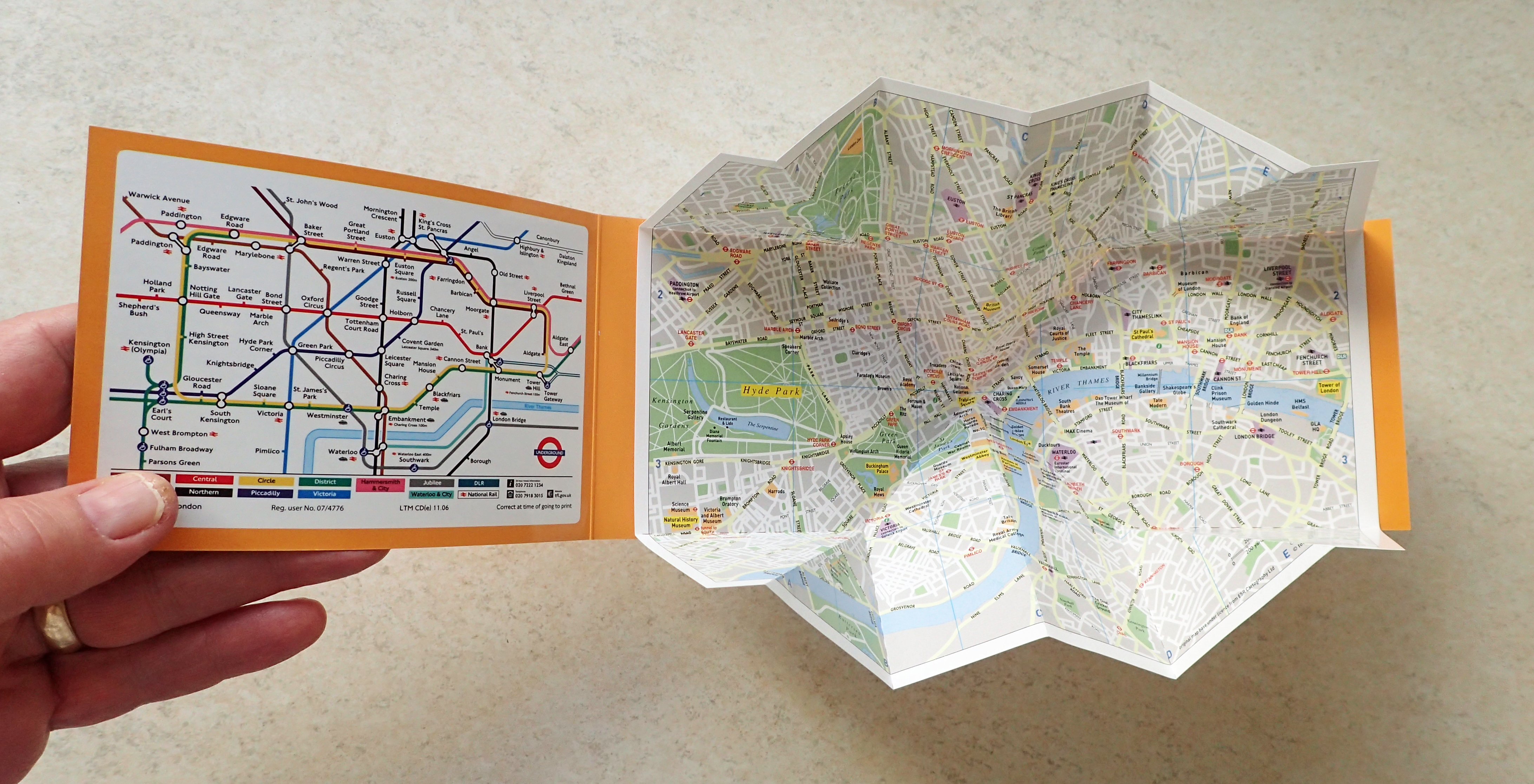
Folding map produced for Post Office distribution and published by thinkmaps. Copyright Trailzoom Ltd. 1996-2007, touristmaps.uk.net 2007
The history of walking London by foot for leisure isn’t a particularly old one. For London residents, the idea of actually exploring it’s streets didn’t extend beyond the Georgian penchant for promenading. This was when the upper class walked the safer streets and green spaces in the late afternoon with the aim of being seen by others in the social elite. None of these well-dressed, and well-heeled, pedestrians were interested in free maps so there was no market for them. Later, at the end of the 19th century this same social class indulged in flâneur- a more strict definition of which was to wander or stroll without purpose other than observation, however this was still mostly an exercise in vanity. Again, there was little commercial point in the production of free maps.
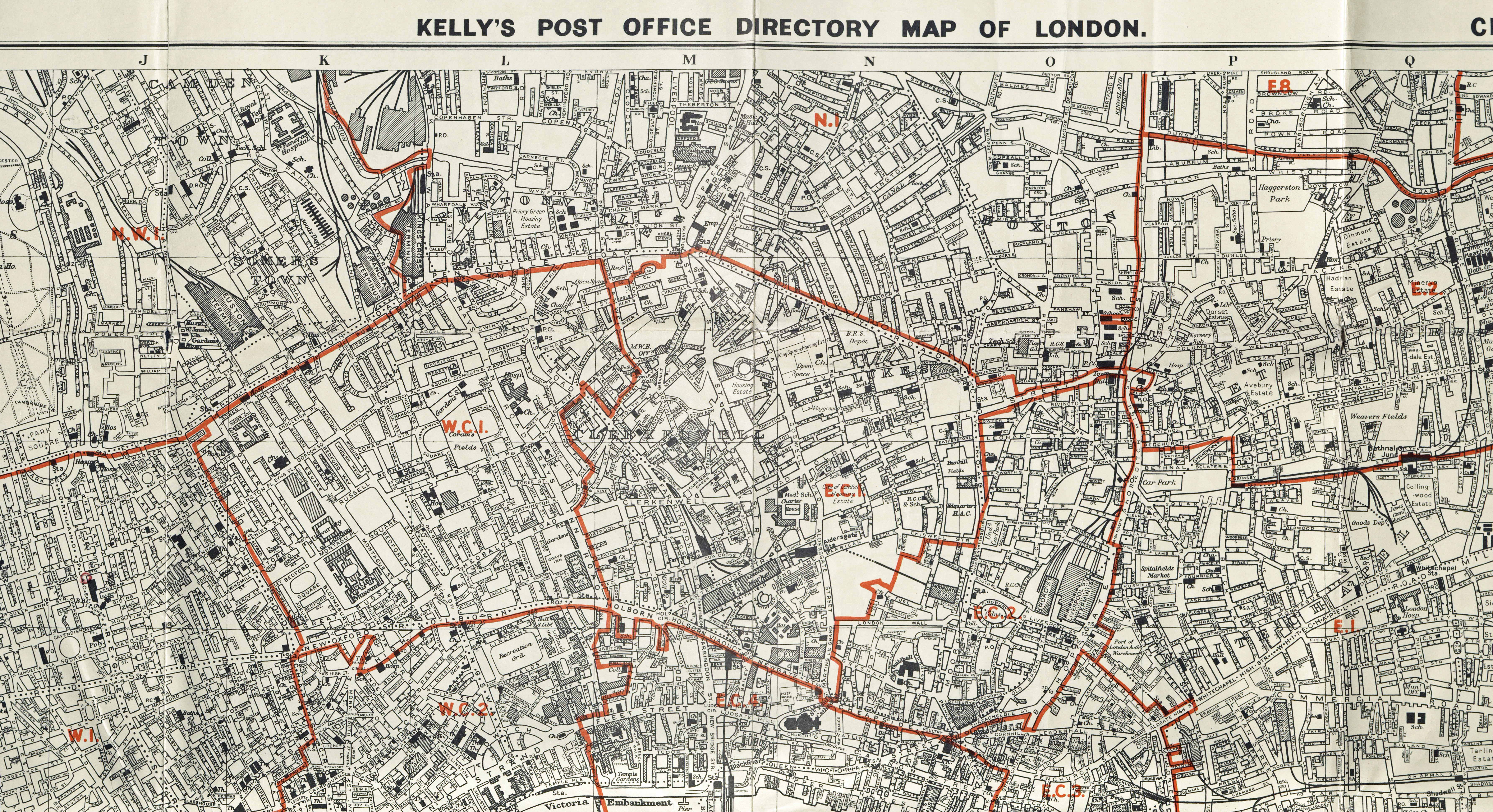
Section from a London districts map prepared by Kelly’s in 1968. The Post Office produced accurate directories and maps from 1800. One of their officials, Frederic Kelly, began producing his Post Office Directory of London from 1836, albeit without official sanction. The Kelly maps were especially detailed and accurate and could be viewed by the public in larger post offices and libraries as well as being available for purchase
1851 saw a massive influx of visitors to London, many for the first time. The majority of these visitors were from the middle and lower classes. They were visiting to view the first ever World Fair taking place in the nation’s capital. This was an exhibition of culture and industry organised by Henry Cole and Prince Albert, husband to Queen Victoria. It took place In Hyde Park, London from 1 May to 15 October 1851 and was a direct response to the successful fairs that France had mounted in Paris since 1798. Over six million people, equivalent to a third of the entire population of Britain at the time, visited including Charles Darwin and Charles Dickens. Though in reality some visitors went two or more times. For this event, new time visitors to London could, quite literally, follow the crowd, and an intimate knowledge of the streets was not necessarily required.
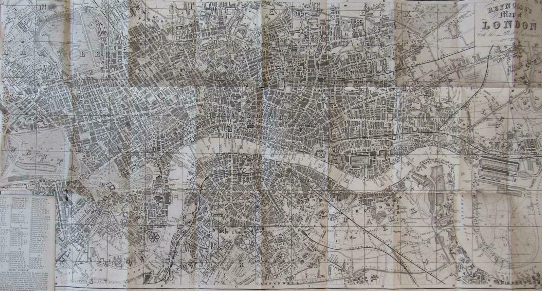
Map of London (part) for visitors to the Great Exhibition, 1851. Drawn by H. Martin, published by James Reynolds
An excellent map of both London and the park itself, together with helpful information was drawn and engraved by Henry Martin, 8 Dyers Buildings, Holborn, and published by James Reynolds but, like the exhibition itself, this was intended to turn a profit. It cost 1 shilling, which was a fifth of the cheapest cost of entry to the newly built Crystal Palace itself. While most members of a party taking advantage of the special rates provided by the railway companies would not have purchased such a thing, they would no doubt have consulted a copy held by their group leader, frequently the local town vicar. Beyond viewing such a map purchased by someone else, there was very little, if anything, available for free for someone to use when walking in central London or it’s fringes. Beyond a visit to the exhibition itself, within the map’s accompanying booklet was good advice on the best way to explore London:
“the best way for a stranger to ascertain the plans of London is first to explore what may be termed its arteries- the main thoroughfares and lines of street which divide it longitudinally. Starting from Hyde-park along Piccadilly, turn down St. James’s street and continue along Pall-mall, by Charing-cross, the Strand, St. Paul’s and Lombard-street, to Whitechapel Church,; and return by Leadenhall-street and Holborn, and along Oxford-street to Hyde-park. This will be a walk or a ride of about nine miles through the heart of the metropolis. He may afterwards make another circuit by passing from Charing-cross southward, crossing Westminster-bridge, passing the obelisk, and reaching London-bridge by the Borough, Gracechurch-street and Bishopsgate-street, will conduct him to Shoreditch Church, and, turning short to the left, he may return to Charing-cross, by the City-road, Kings-cross, New-road, Edgeware-road, Park-lane, Grosvenor-place, Pimlico and Westminster Abbey. This will be a route of about eleven miles”
London transport maps
Probably the earliest free paper maps that anyone could practically use for walking to a destination in London were those produced in the late nineteenth century by the London transport companies. These companies needed to show where their routes lay and encourage workers and travellers to use their services. Such maps continued to be produced into the 20th century in ever increasing numbers and formats and production continues to this day. Maps showing tram, omnibus/bus and coach routes would overlay lines and stations over a street map. Some would also show the route of the London Tube system that lay mostly underground. Available for free, they were often perfectly adequate for anyone who chose to walk rather than ride. However every now and and then quite terrible maps have been produced.
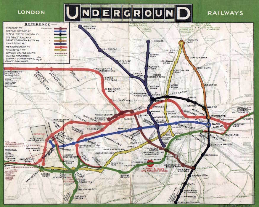
The first public map of the London Underground showed the lines overlain on a street plan. However the map was not particularly helpful to those travelling above ground, nor those underground. 1908
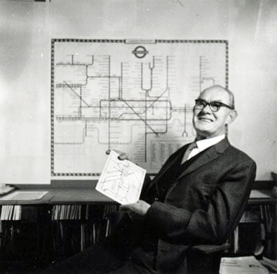
Harry Beck, the man responsible for the radical redesign of the London Tube map
The first maps of the London Underground system had normal street maps and the lines of the underground railways superimposed. This was replaced in 1921 with a tube network map with above ground detail other than stations and the River Thames omitted. This was more than adequate for underground rail travellers but obviously of no use to those walking above ground.
The central area of the tube map was squashed and Harry Beck’s idea of expanding the central area, distorting above ground geography and making the map schematic rather than geographic, was a step change in map design.

Map of the General Omnibus Routes provided free to the public by the London General Omnibus Co. Ltd. 1928
A striking step-change it may have been, but of limited help to those walking London streets. Despite mirroring the success of the Beck Underground maps, some bus maps have occasionally fallen victim to producing similar diagrammatic maps that failed miserably to support anyone attempting to navigate London’s complex streets.
Where bus maps have worked best for the pedestrian is, fairly obviously, when a geographical style has been retained. All the better both for a passenger to themselves in relation to the streets being passed through, but also for onward journey by foot. One of the best features of these maps, both bus and tube, is their pocket sized dimensions. The folded 1928 Omnibus map shown below measures just 75mm x 144mm when folded. These are almost the same dimensions as a 2019 tube map I have on my desk in front of me- 75mm x 150mm.
Drawn by the accomplished artist, illustrator and cartographer Alfred Edward Taylor, the Map of the General Omnibus Routes is both attractive and practical, if a little small scale for those hoping to use it for navigation by foot, as it covers all of Greater London.
Map of the General Omnibus Routes, issued free by the London General Omnibus Co. Ltd. Drawn by Alfred E. Taylor, the map is an ideal size for use in the hand. Printed by Waterlow & Sons, 1928, however map design is dated 1927

Bus map to the central London area. Published by London Transport and issued free. 1946
The bus and tube companies seem to have hit on the optimum size for their free maps almost from the outset. The map above, held by Three Points of the Compass, measures 445mm x 577mm when open.
The rear of the map, in common with almost all others likewise produced, is stuffed with information for the traveller. On these earlier maps almost all information relates to routes, destinations, days of operation etc. It was only later, when attempting to attract the tourist and non-commuter, that more general information of places of interest was included.
In contrast to the attractive and intuitive map design above, the bus map below follows a diagrammatic style, even altering the gentle flowing curves of the River Thames to something more akin to that found in an electrician’s manual. I don’t like it and many who used it didn’t either and a return to more practical freely issued maps for bus routes was not long following.
Bus map drawn by J.H. Elston and printed by Waterlow & Sons. More like a wiring diagram than a street map, it would take the most determined of map reading bus goers to navigate London successfully with it. 1946
Compare the above diagrammatic style with the 1959 example below. Though simple and omitting streets, it is nonetheless easy to follow on the ground and more than sufficient for the pedestrian to find their way across the part of London shown.
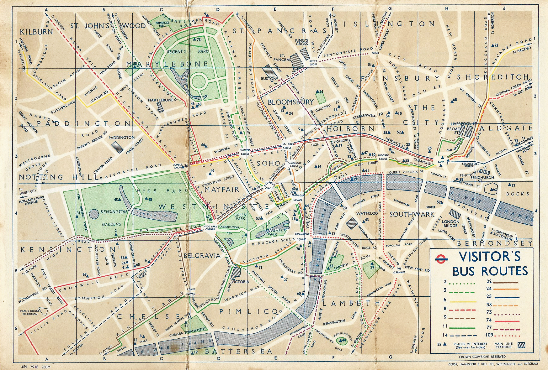
Small free street map showing fifteen bus routes taking passengers to places of interest in central London, with sufficient information to walk between them. Map measures 228mm x 152mm. Published by London Transport, 1959
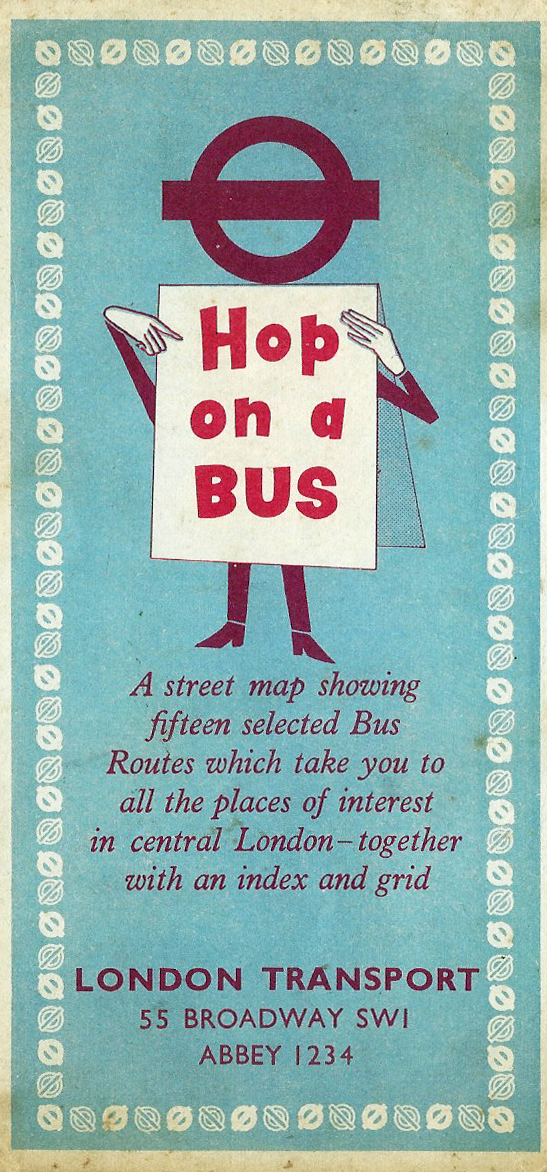
Small pocket map with Hop on a Bus character that first appeared on posters in 1958. Published by London Transport in 1959
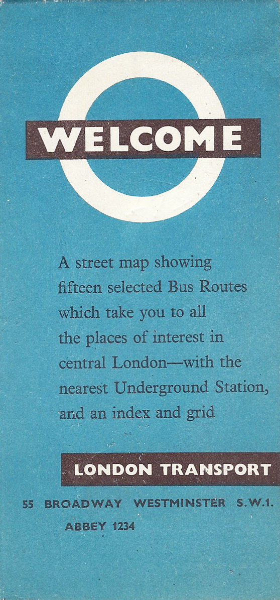
London Transport ‘Welcome’ map produced by London Transport detailing fifteen bus routes taking in ‘places of interest’. 1964
Following the Second World War there was a push to reinvigorate the tourist and general visitor presence in London. Some beautiful and detailed maps were produced but all, perhaps unsurprisingly, appear to usually have a purchase price associated with them. For someone looking to simply walk the streets of London with the minimum of outlay, the maps produced by the bus companies were probably their best option.
London Transport began to produce bus maps specifically targeting both the generally inquisitive and the tourist. In the 1960’s, a range of maps was produced that included a potted history of London buses on one side and and selected routes, by bus, across the capital on the other. These are well produced but omitted considerable surface detail. For anyone sticking to major routes and streets however, they were, and are, clear and simple to read.
My usual benchmark to how useful a free map is to pedestrians is how Hyde Park is shown, or even if it is shown. Most maps will show West Carriage Drive crossing the park, but how do they depict the many paths crossing the extensive grounds, if at all.
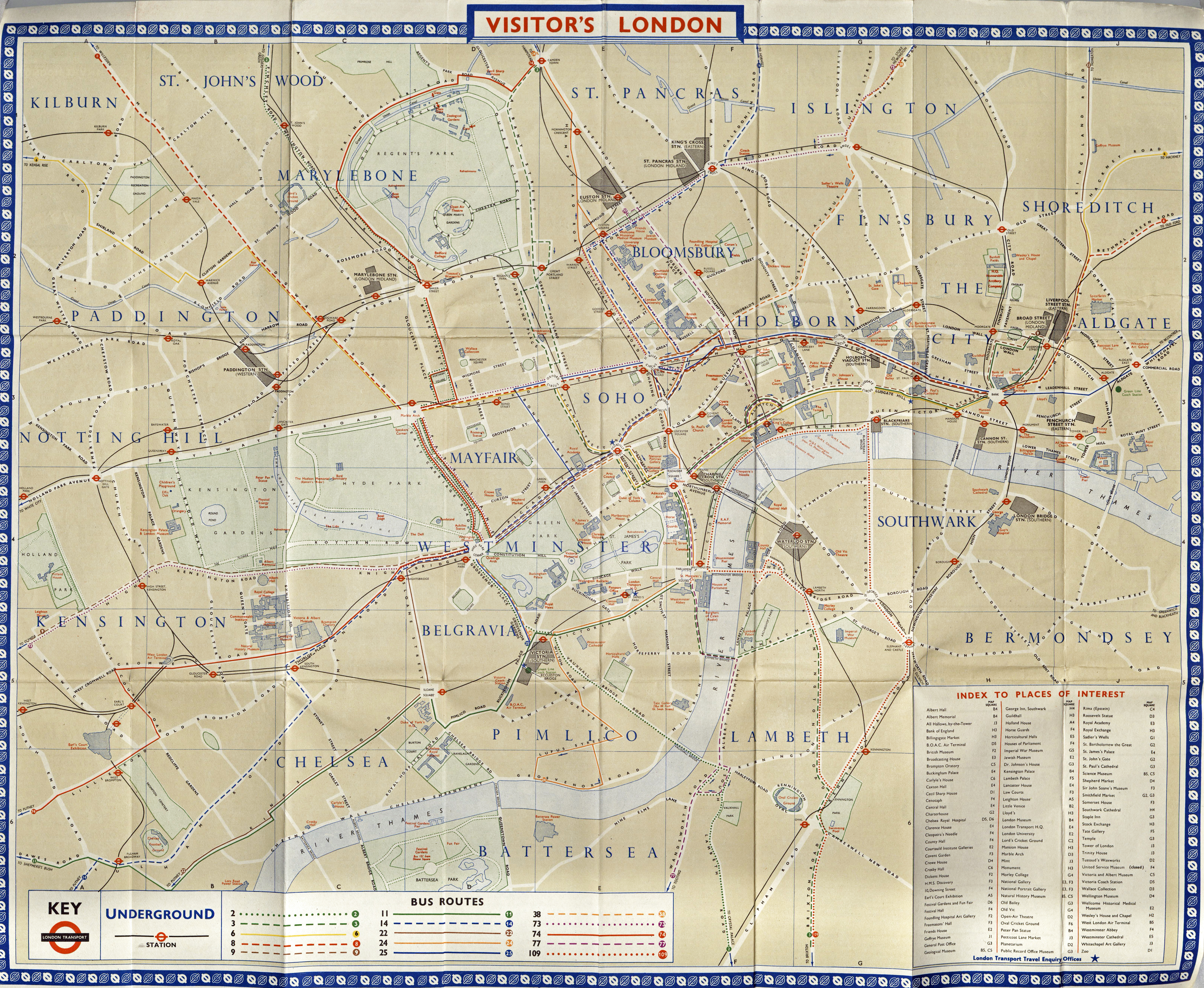
Though attractive in design, this 1964 bus map has simplified London to only show major streets, bus routes and places of interest
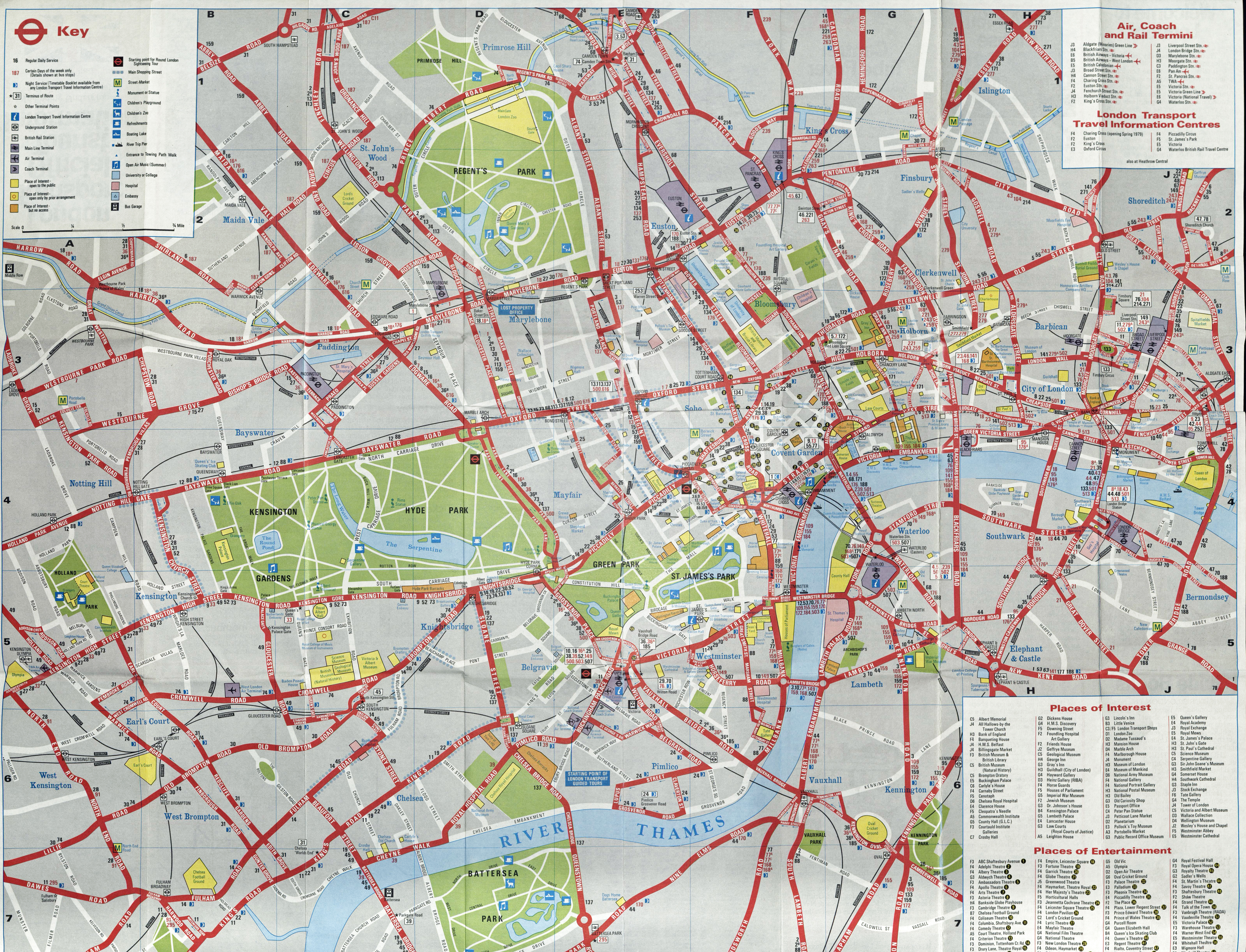
Free map of London showing maps and routes across both Greater and Central London. April 1976
Bus maps did not improve much in the 1970s. Only essential detail was added, enough for the bus traveller for whom the maps were intended of course, but little use for anyone hoping to pick up a free map that would assist them in exploring London by foot.
The map shown immediately below was included on the back of a 1976 bus route map issued free by London Transport. Another map, also drawn in 1976 and shown below, was included on a free bus map issued in 1979. Slightly larger in format, a tad more detail is included. Using my yardstick of Hyde Park, the footpaths crossing that are included together with just some extra streets beyond the major routes.
The designer of both maps was David Penrose. In common with almost every other street map of the capital almost no detail of terrain is shown. It has close similarities to the A to Z maps produced by the Geographers’ Map Company founded in 1936.

Free bus map by London Transport. Detail from rear showing central London routes and minimal street detail. Designer was David Penrose, April 1976
The bus map provided by London Transport in 1979 includes a map drawn in 1976 by the Cartographic Department of Cook, Hammond and Kell Ltd. David Penrose was again responsible for its design
Bus maps have a difficult job. They need to not only give an indication of destination and routes, but also bus numbers and provide a modicum of additional information for the casual visitor and tourist. Sadly, this efficiency is frequently at the cost of attractive design and moving through the 1980s and 1990s, there is little to commend them to either map reader or walker.
Selection of free 1990s bus maps. Ruthlessly efficient and effective for the bus traveller, less so for those walking
Green Line coaches
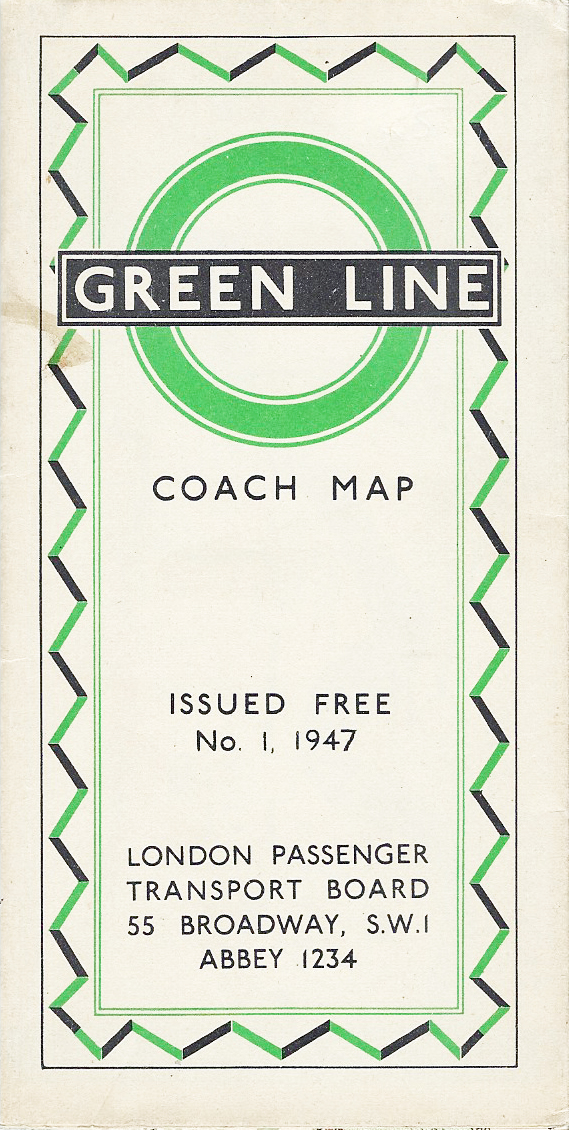
Free Green Line coach map issued the London Passenger Transport Board, 1947
Coach maps are seldom much use when walking in London. Coaches tend to have longer journeys than buses and subsequently have smaller scale maps. Perhaps, at most, including a larger scale representation of streets immediately surrounding a termini.
The London General Omnibus Company registered the Green Line Coach service in 1930. The coaches linked central London with country towns within a 30 miles radius. It was this network that was shown on their maps.
Green Line became part of the London Passenger Transport Board in 1933 and it is a map from this era shown below. Anyone using this map to walk around London would struggle, however it could just about be managed if sticking to coach routes!
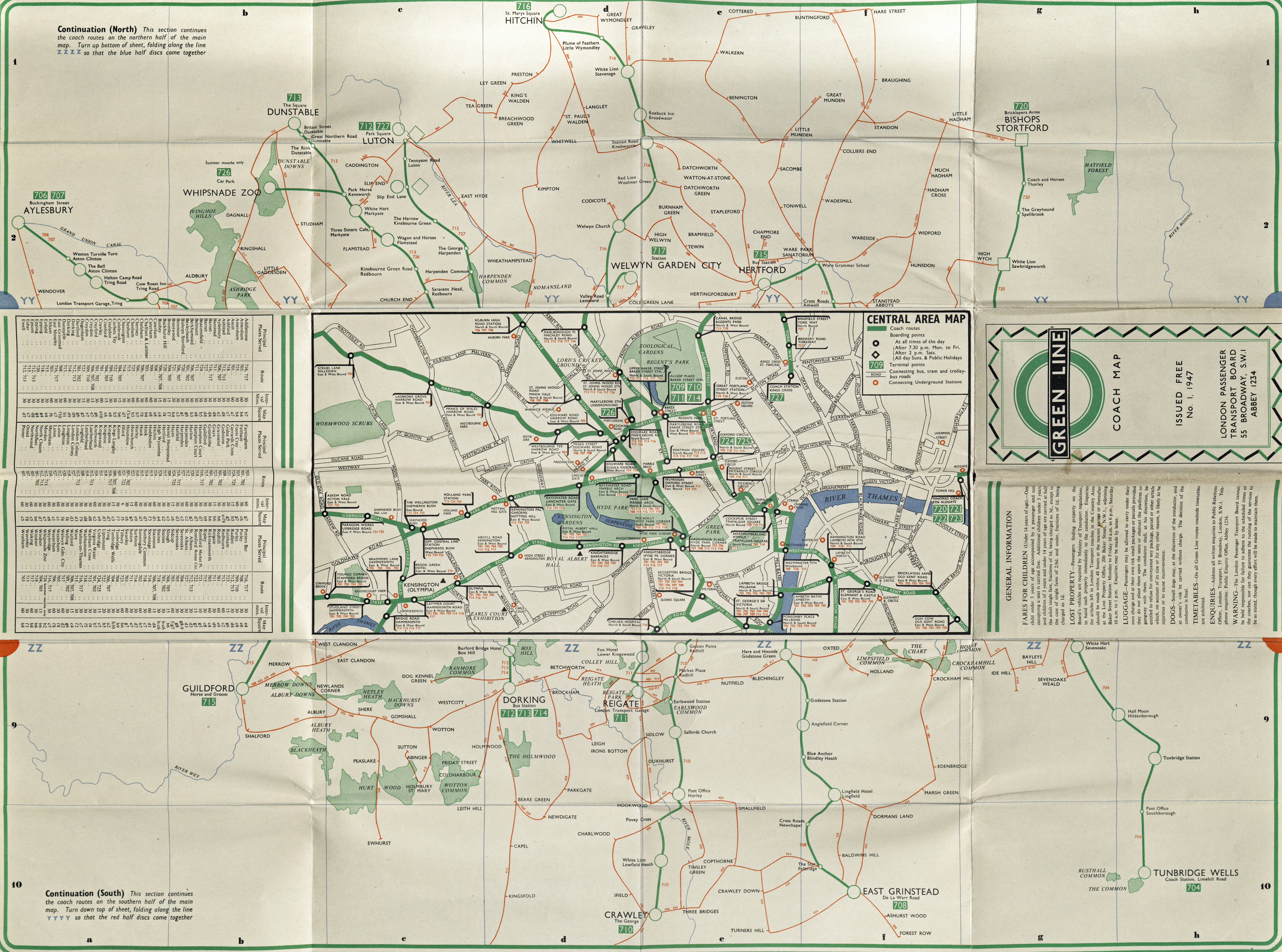
Green Line coach map. Small scale map on the other side can be folded to join up with upper section of map shown here. Central London is shown to a larger scale. Crown Copyright, the map was prepared by J. Weiner Ltd. 1947

Free London map from Green Line Coaches, 1974

French language map from Green Line Coaches, 1972
The London Transport Board transferred their country coach and bus division to the National Bus Company in 1970. The coach map below was produced by the newly created subsidiary- the London Country Bus Services Ltd. The coach service was by now a pale imitation of its 1950s excellence. Battling to modernise an aged fleet and modernise their image and improve profits, maps were also produced to encourage and assist overseas visitors.
I say maps. They are amongst the worst maps illustrated here and show almost zero artistic flair and very little information beyond the actual roads utilised by one coach or another.

Small map on 1974 Green Line leaflet shows little more than a minimum of streets in central London
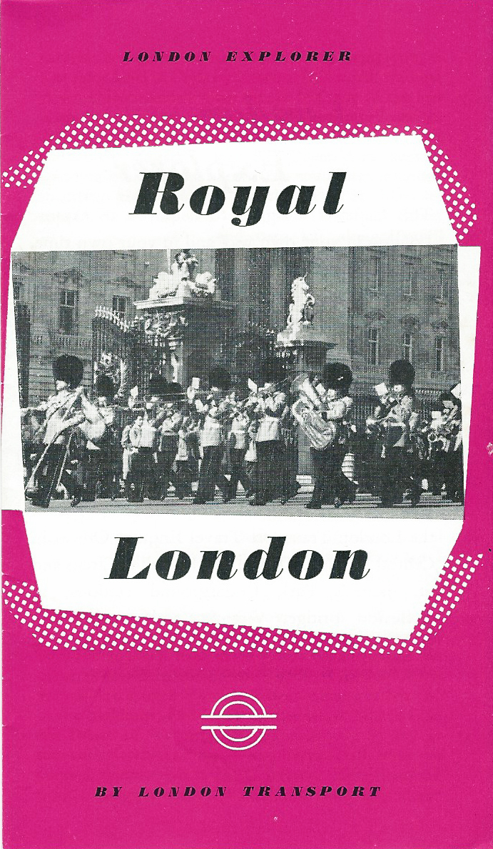
Free leaflet detailing a walk through just a part of ‘Royal London’. Printed June 1965

Free leaflet detailing a walk in London and advertising a guide book ‘Visitor’s London’, price five shillings. Printed March 1965
In common with other transport companies, Green Line were also behind the production of leaflets aimed at the general tourist. With the specific aim of increasing use of their services outside general commuter traffic, a range of cheaply produced free leaflets were prepared detailing short walks through London. Accompanied by a modicum of accurate historical detail the maps include just enough information to follow by foot, but are insufficient to wander ‘off-piste’.
A further aim of the leaflets was to encourage people to buy London Transport’s official guide book for tourists- ‘Visitor’s London‘. Costing five shillings and written by Harold F. Hutchison, the guide was printed annually and was:
‘an alphabetic reference book for the visitor to London who wishes to also see something of London’s countryside’.
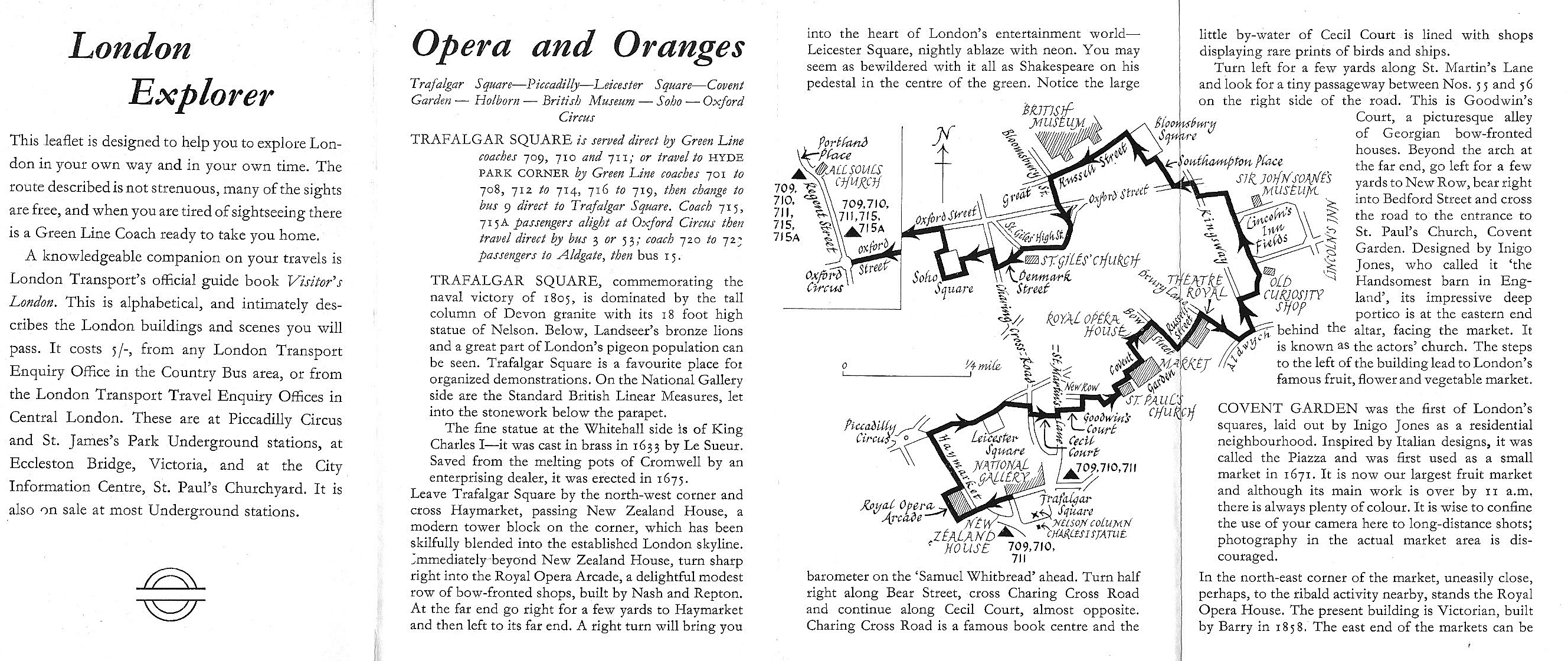
Part of the detail within the free walk leaflet ‘Opera and Oranges’. Produced by London Transport, these leaflets were aimed at people living within a thirty mile radius of London and was intended to increase use of transport during quieter times of the day. Printed March 1965
Motoring Associations
Motoring associations also produced maps for their members. Some of these could be purchased while others were issued free with membership. Founded in 1897, the Automobile Club of Great Britain (and Ireland)- the second oldest motoring club in the World, had prepared a London map for its members prior to it receiving Royal Charter and being renamed the Royal Automobile Club (RAC) in 1907.
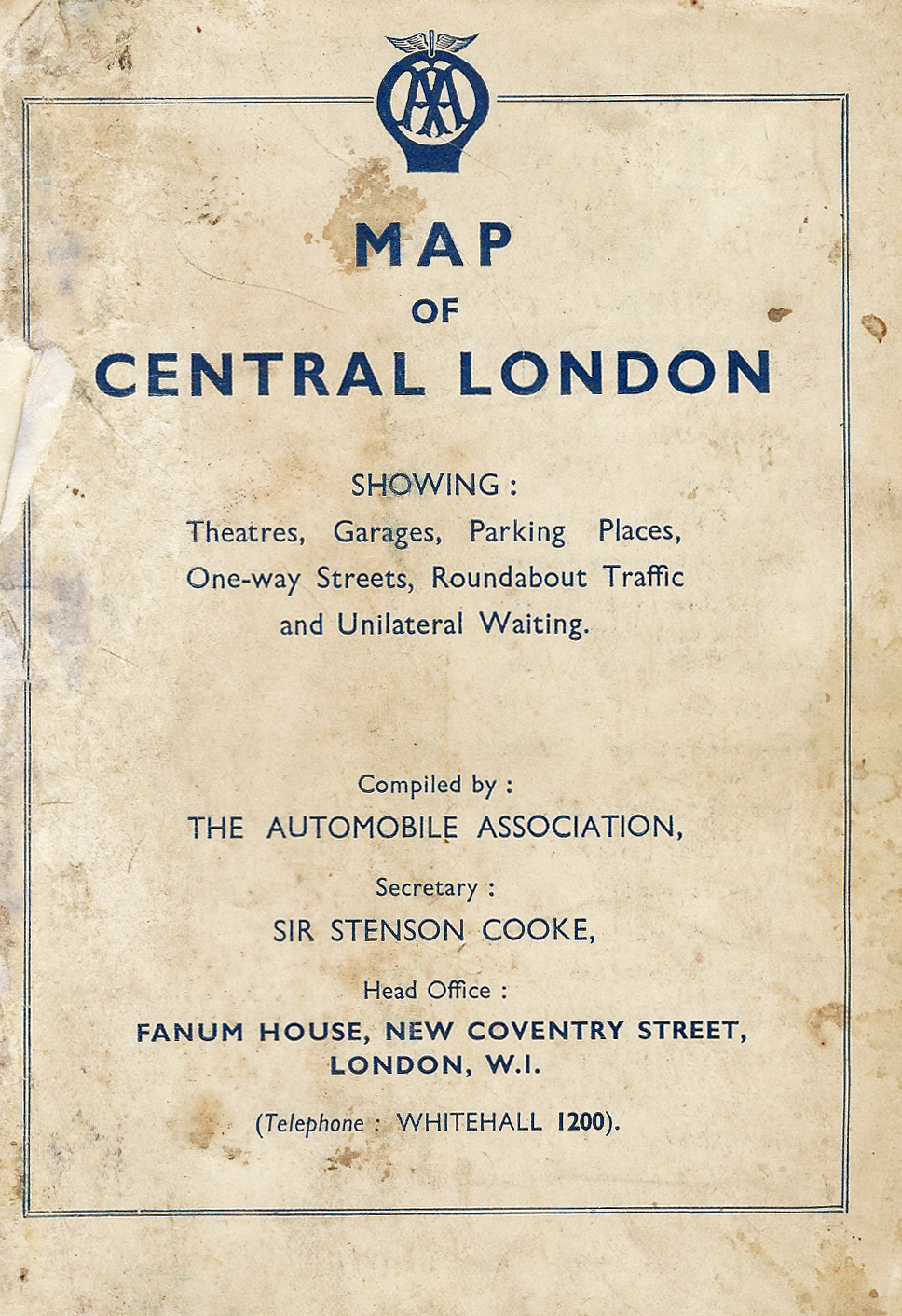
Map to central London produced by the Automobile Association, circa 1935
The road maps produced by the Automobile Association (AA) are not only of use to drivers, they contain good information for those on foot too. The AA produced ‘through routes’ for its motoring members but demand for these fell when wartime petrol rationing was introduced.
When petrol rationing ceased in 1950, demand for maps again rose and with a membership in excess of 700,000 clamouring for good maps, many excellent town maps were produced.
“members are reminded that, in addition to this map, the Association issues a number of publications of service to the motoring visitor to the Metropolis. These booklets may be obtained free of charge at any A.A. Office”
In addition to the 1935 map shown below, members could be provided, free, with London Route Maps, a London Guide, a map showing garages adjacent to London Railway Stations and a map showing garage and parking places in the vicinity of the Olympia exhibition halls.
Map of Central London issued free to members of the Automobile Association, 1935
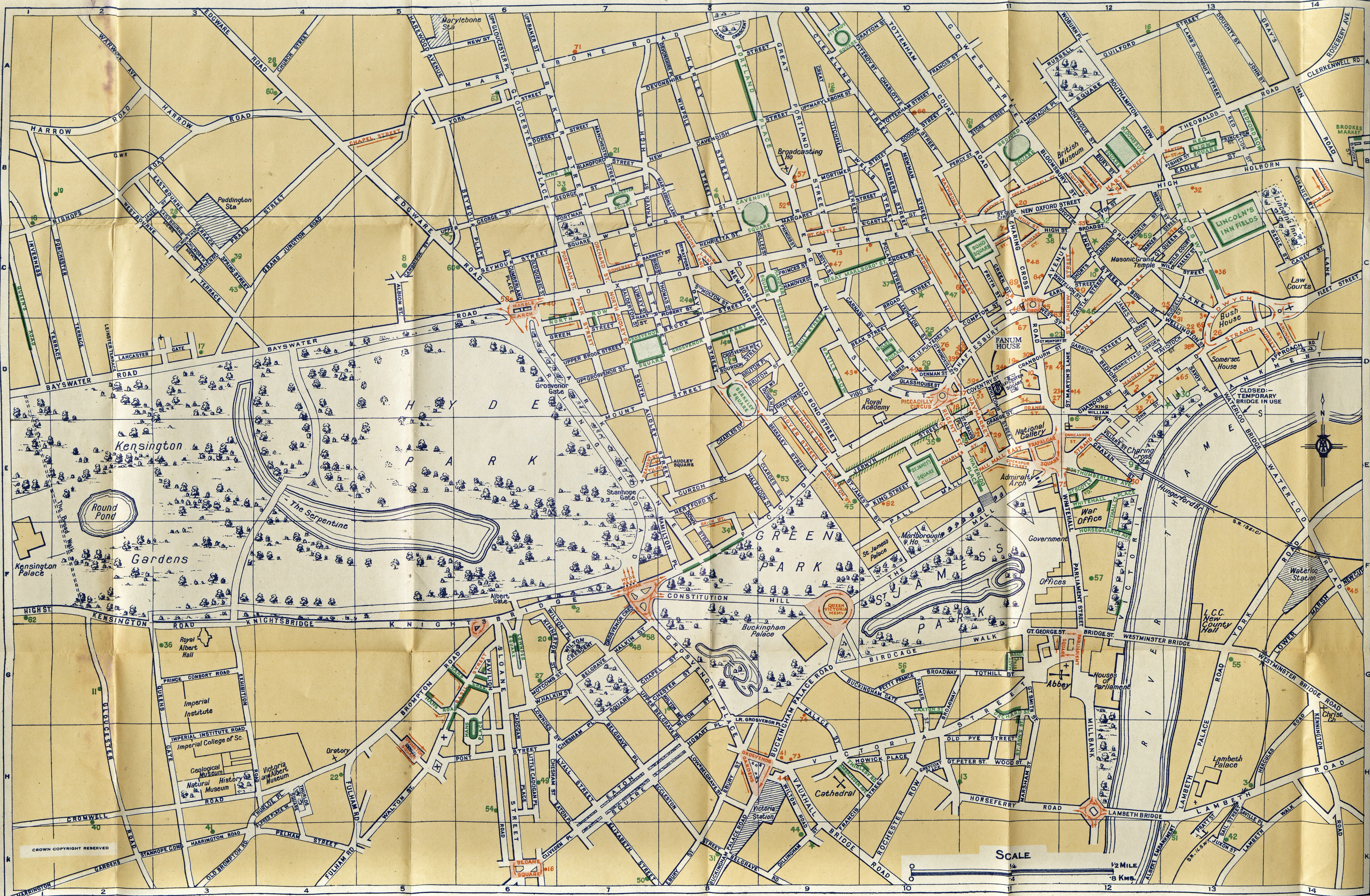
Map showing the London West End & routes into London. Printed by John Bartholomew & Son, Edinburgh, circa 1954
The small section of map shown below, and taken from a larger sheet, was produced by the Automobile Association (AA) in the years immediately following the Second World War and was not only intended to illustrate the best motoring routes into London and the West End, but also show garages, official parking places, parking places on bombed sites, ‘no waiting’ streets, theatres, cinemas and hotels.
Drawn and published by the AA, it is printed in three colours. Part of the map was based on aerial photography by Hunting Aerosurveys Ltd. Copyright by the Automobile Association and C. J. Cousland & Sons. The remainder of the map is based on Ordnance Survey Maps. Scale is 1/3 mile to the inch on one side and 1 mile to 13 inches on the other. A detail from the map above is highlighted below.
One of the bombsites in London shown on the AA map had been acquired by Ronald Hobson and Sir David Gosling in 1948 for private parking and this facility enabled them to form Central Car Parks. In 1959, they took over National Car Parks (NCP), who were the UK’s oldest private car park operator (founded 1931). NCP went on to produce free city maps, including London, showing the location of their car parks. Frequently these were produced in collaboration with a partner.
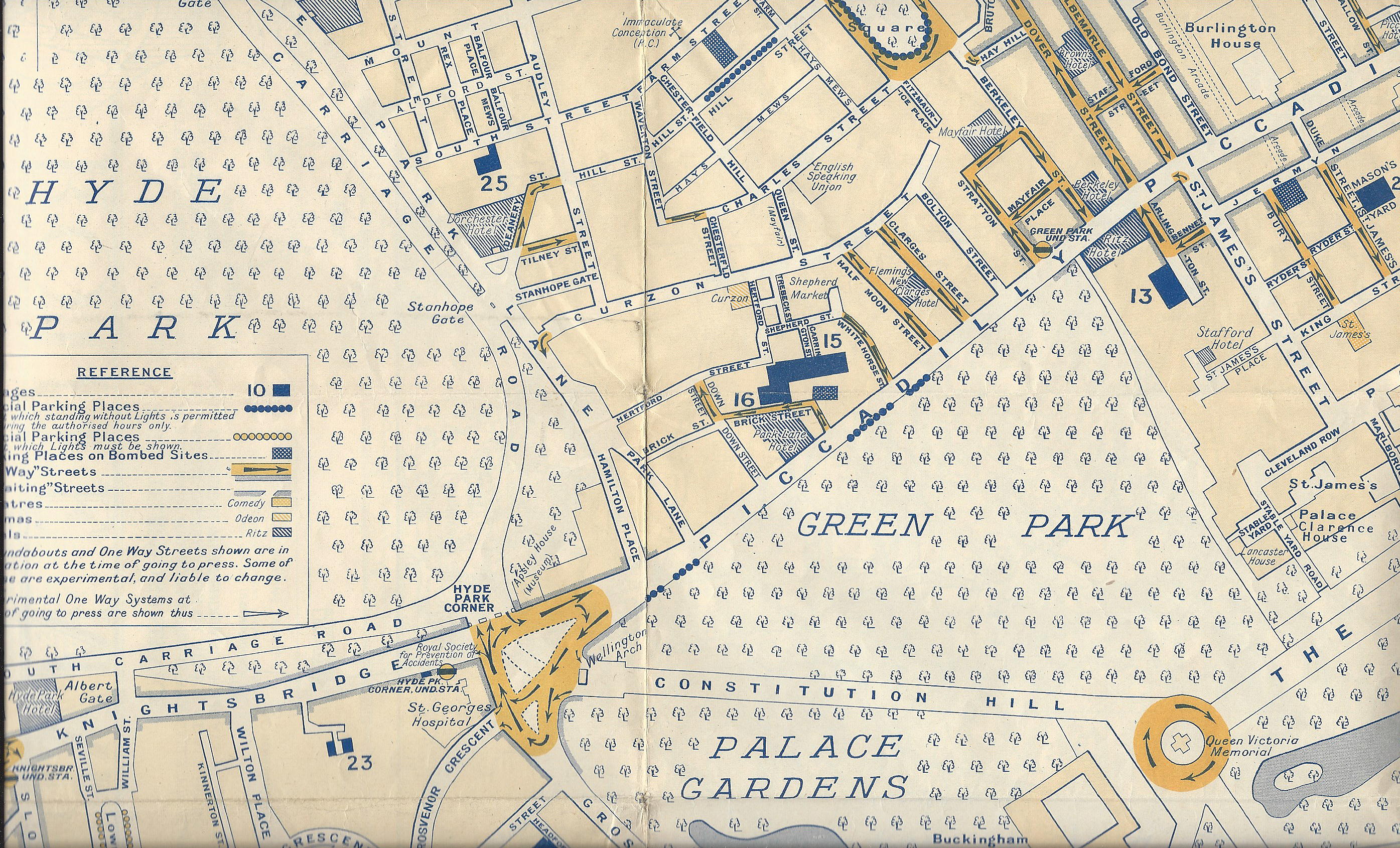
Detail from centre of AA map, circa 1954. Despite the large scale, Hyde Park is simply shown as a wooded area, ignoring any paths. Note the inclusion of bombed areas temporarily re-purposed as parking spaces
And what of Hyde Park. The target audience- motorists, for this map is all too obvious. Compare this with the extra detail on the maps supplied by Hermetite and the London Co-op shown below.
Banks
Many banks would encourage new savers and customers with free giveaways. For a period, these included useful street maps, which obviously included detail on where bank branches were situated.
Simple map of inner London included in complimentary booklet distributed by Barclays Bank for the 1937 Coronation of King George VI. The processional route was also included in this booklet and can be seen in part three of this series

Free map produced by Barclays Bank for visitors to London. Designed by E.W. Fenton, 1970
While Hyde Park is shown on the Barclays Bank complimentary map produced in 1970, little is included beyond an un-named West Carriage Drive and the Serpentine. The map does show the locations of the bank’s branches in central London and also sought to explain the intricacies of the forthcoming ‘D Day’ on 15th February 1971, when Britain made the change to decimal currency. Written and prepared by the bank’s advertising department and designed by E.W. Fenton, A.R.C.A., it was printed by Davenport, Askew & Co. Ltd.
Quite simple in design, streets are over exaggerated and simplified. Major destinations and Underground Stations are shown, along with a Tube Map designed by Paul E. Garbutt. Another map with an enlargement of the central area was included.
Detail from map released by Barclays Bank in 1970. Scale is 5cm to the mile
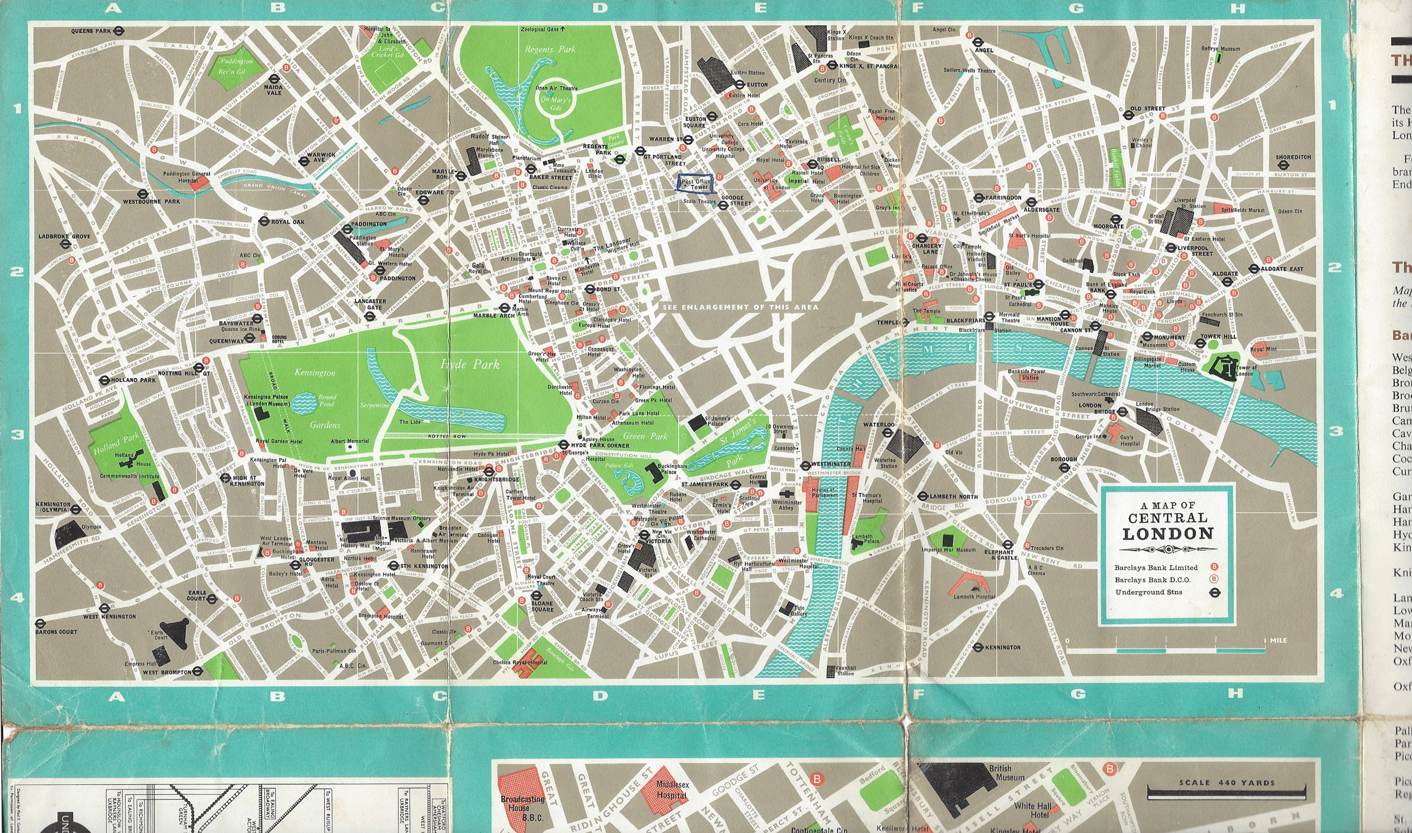
Complimentary map booklet produced by Hermetite for it’s customers in 1961
The booklet shown here was produced by Hermetite in 1961 and distributed free of charge to its favoured customers, mostly trade. No-doubt those ‘in the know’ would be able to obtain one of these expensively produced booklets that contain twenty-three good street maps derived from Ordnance Survey maps, together with another four maps providing further detail for visitors.
Hermetite made automotive products and was acquired by Hammerite in 1985. In a day where tote bags, pencils, T-shirts and over-sized mugs are given away in their thousands to favoured customers and visitors to company trade stands and outlets, the earlier production of such a useful and accurate map is extraordinary.
This booklet has been further overprinted in 1962 with detail on where the Hermetite trade stand was located at the Motor Show taking place that year at the Earls Court exhibition buildings.
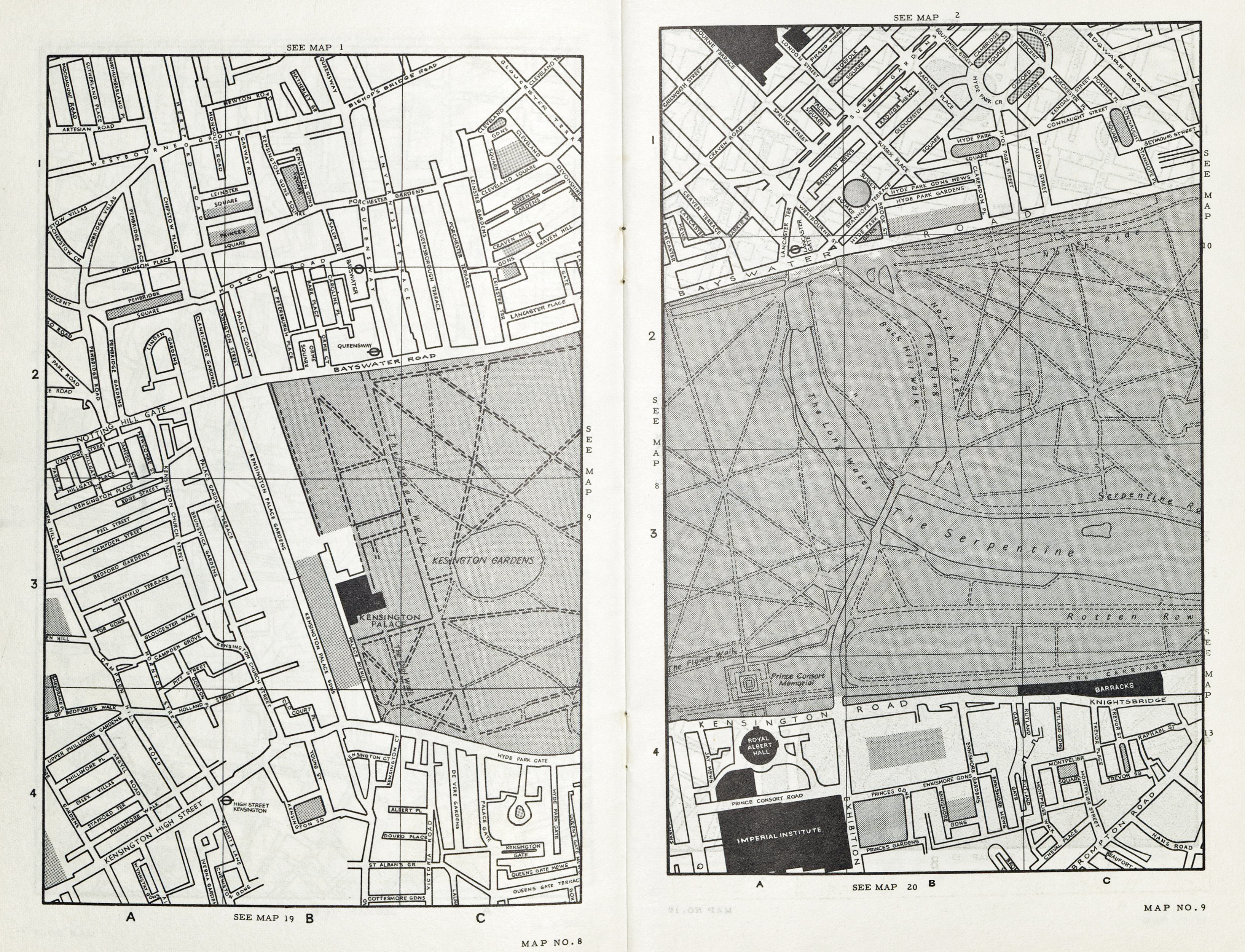
Maps 8 and 9 in the free London street atlas provided by Hermetite in 1961
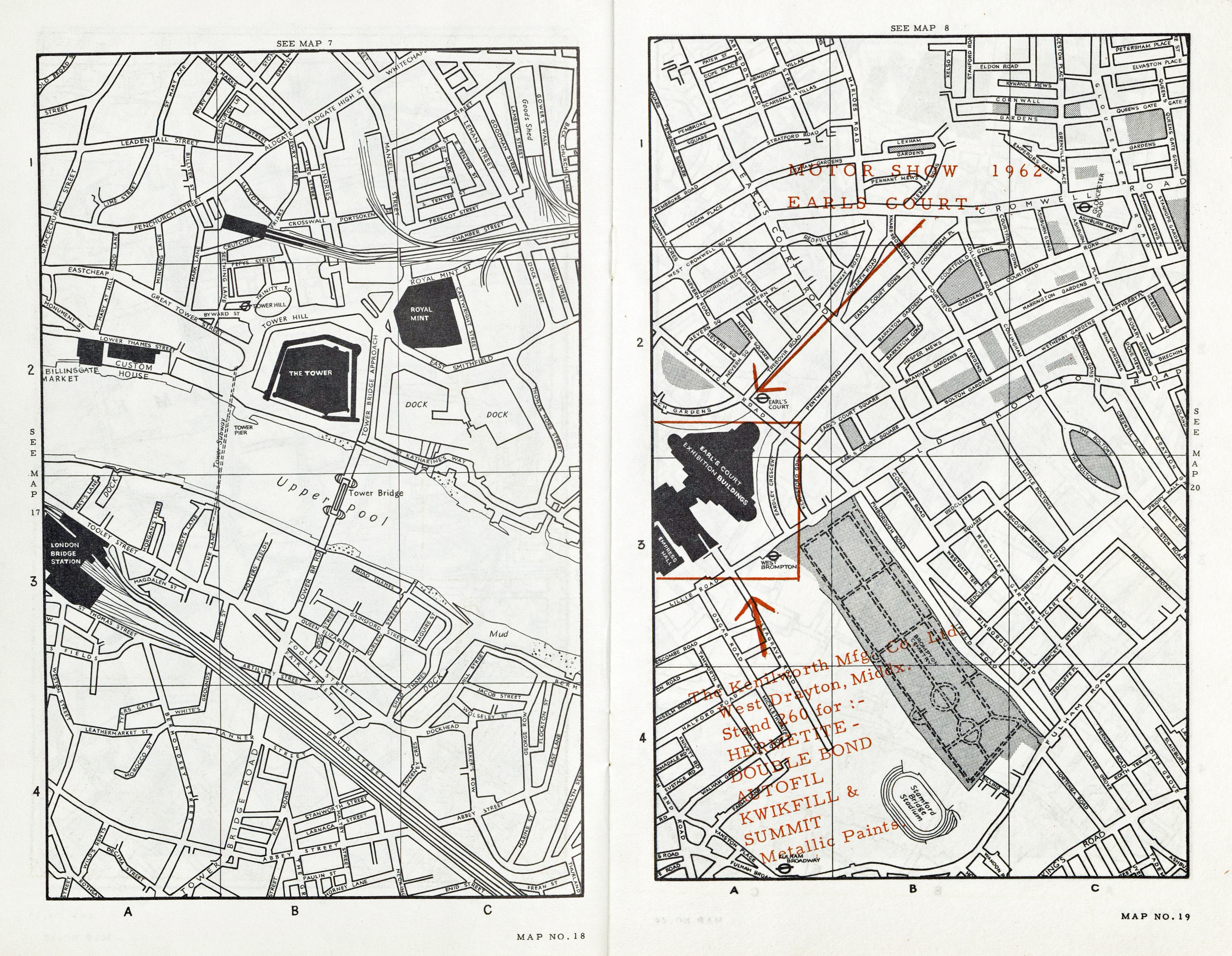
1962 overprint in Hermetite booklet provided for it’s customers

Map given free of charge to shareholders in the London Co-operative Society
Co-operative shareholders
Beside banks there were some unexpected places where good street maps to London could be picked up. Anyone who was a shareholder in the London Co-operative Society, entrance fee one shilling in the 1950s plus another shilling for the first share, could expect a map showing the location of every Co-op service outlet. The map shown probably dates to the early 1960s and shows the society’s main department stores and centres.
Printed almost exclusively in black, the map was prepared by G.I. Barnett and is based upon Ordnance Survey maps. A great deal of information is provided for shareholders and anyone else to whom the map was distributed “with the compliments of the committee…”. Beside good street detail and an index to places of interest, also shown is the location of Co-op stores, cinemas, theatres, close up of the Oxford Street shopping area and the London Transport system.
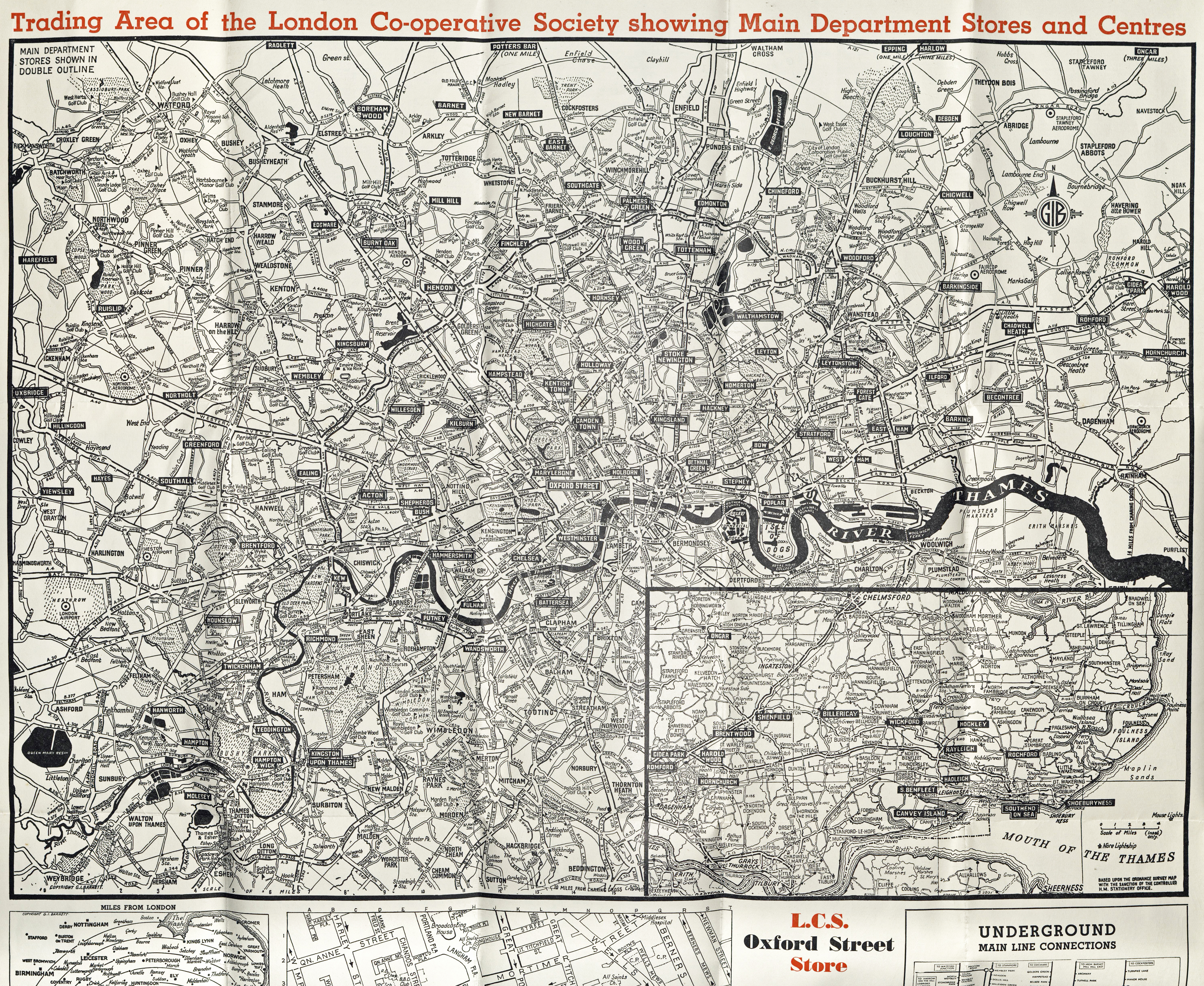
Trading map of the London Co-operative Society. c1960
While the main map provided by the co-op is of most help to motorists, the map on the reverse shows in far greater detail the street and parks on central London and would be ideal for the pedestrian. Click on the image and you will see how this map shows detail in Hyde Park that is barely covered on any alternative.
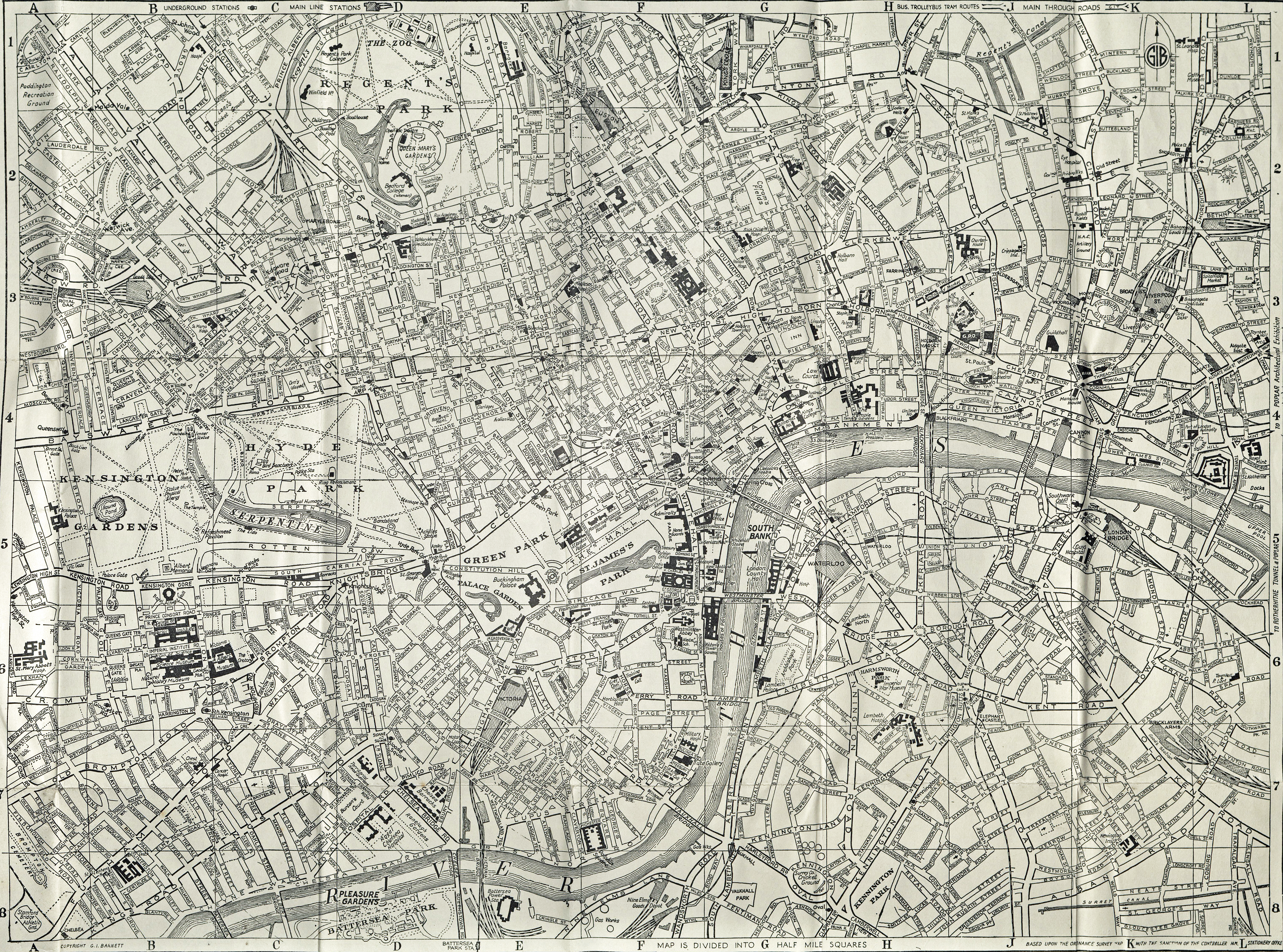
there is a lot of fine detail map provided on the map supplied by the London Co-operative Society, look at how much is included for those visiting Hyde Park- paths, statues, refreshments and bandstand are amongst the places shown
Estate agents
Anyone looking to purchase or rent a property would frequently be supplied with a free map of the local area. This enabled a buyer to orientate themselves and gain a flavour of the area immediate to the property of interest. What parks were in the area, how to walk to local shops and facilities, how to best commute etc. While the 1980s and 90s often saw poor quality photocopied maps being handed out, prior to this an estate agent frequently produced good quality maps bespoke to their business. Cost of production would be offset by the inclusion on the map of advertising for local businesses.

Part of a map to the Hampstead area of north London. This has been produced by cartographers Geographia and is based on Ordnance Survey mapping and is overprinted with the location of the estate agent’s office. Printed by Waterlow and Sons Ltd, probably in the 1960s
Travel agents and airlines

Small map produced by travel agent Thomas Cook for its customers. Production costs were largely met from advertisements on its reverse which included advertising for the Ivy Restaurant. 1954
The travel company Thomas Cook was first formed in 1841 to carry temperance supporters between towns and cities by railway. Cook also arranged transport to the 1851 Great Exhibition, mentioned earlier. Travel tours to Europe followed in 1855 and to the US in 1866.
The map shown here was produced in 1954 and supplied to its customers exploring London. Though small (342mm x 221mm) the three colour map shows central London and its tourist highlights, together with addresses of the Thomas Cook London offices. Though sadly, paths across parks get short shrift.
Despite including little detail for walkers across green spaces, it is a simple and accurate map, as befits the cartographer- Geographia Ltd. This map publishing company was founded in the UK in the early 1900s by Hungarian Alexander Gross. Geographia were also responsible for the map shown above, printed for estate agent Potters.
The Thomas Cook Group ceased trading in September 2019. Such was its suddenness, that some 150 000 UK customers were left stranded abroad resulting in the UK’s largest peacetime repatriation.
Small map of central London produced by Geographia Ltd and supplied free of charge to customers of travel agent Thomas Cook. 1954
1971 PanAm map and guide
Drawn to a scale of 1:11 000, the 1970 map supplied to its passengers shows west, central and eastern London on one side
In these days of budget airlines where almost any ‘extra’ has to be paid for, it can be hard to comprehend that travellers with some airlines were offered ‘free’ maps, though the cost of producing these would have been swallowed up as part of their ticket or excursion price.
I show two ‘airline’ maps here- first is a 1970 map supplied by Pan American Airways. An international affair, it is copyright Falk-Verlag of Hamburg Germany, based upon UK Ordnance Survey maps and printed in the U.S.A.
Detail- from 1971 PanAm map supplied to its passengers, shows NW, W and SW London on one side.
The map is a garish affair with bright pink blocks, interspersed with green areas depicting parks and gardens, criss-crossed by bright yellow roads. It is folded into the front cover of a small booklet. This supplies information to travellers on currency, taxi fares to be expected, tipping, weather, what to wear, where to visit, stay and eat, night life, theatre and music. However for the urban pedestrian, the map is the most helpful inclusion. Far more useful than the tiny maps included in most modern city guides.
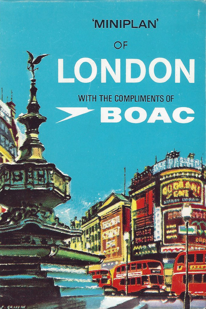
Free map provided to airline passengers by BOAC. Cover design by F. Griffin. Produced by Miniplans Ltd. 1960
The second ‘airline’ map shown here dates from a decade earlier. Produced by British state owned airline British Overseas Airways Corporation (BOAC) and given free of charge to its travellers, the map folds small enough to easily fit within a pocket- 85mm x 127mm. However, unfolded, the maps measures 568mm x 340mm.
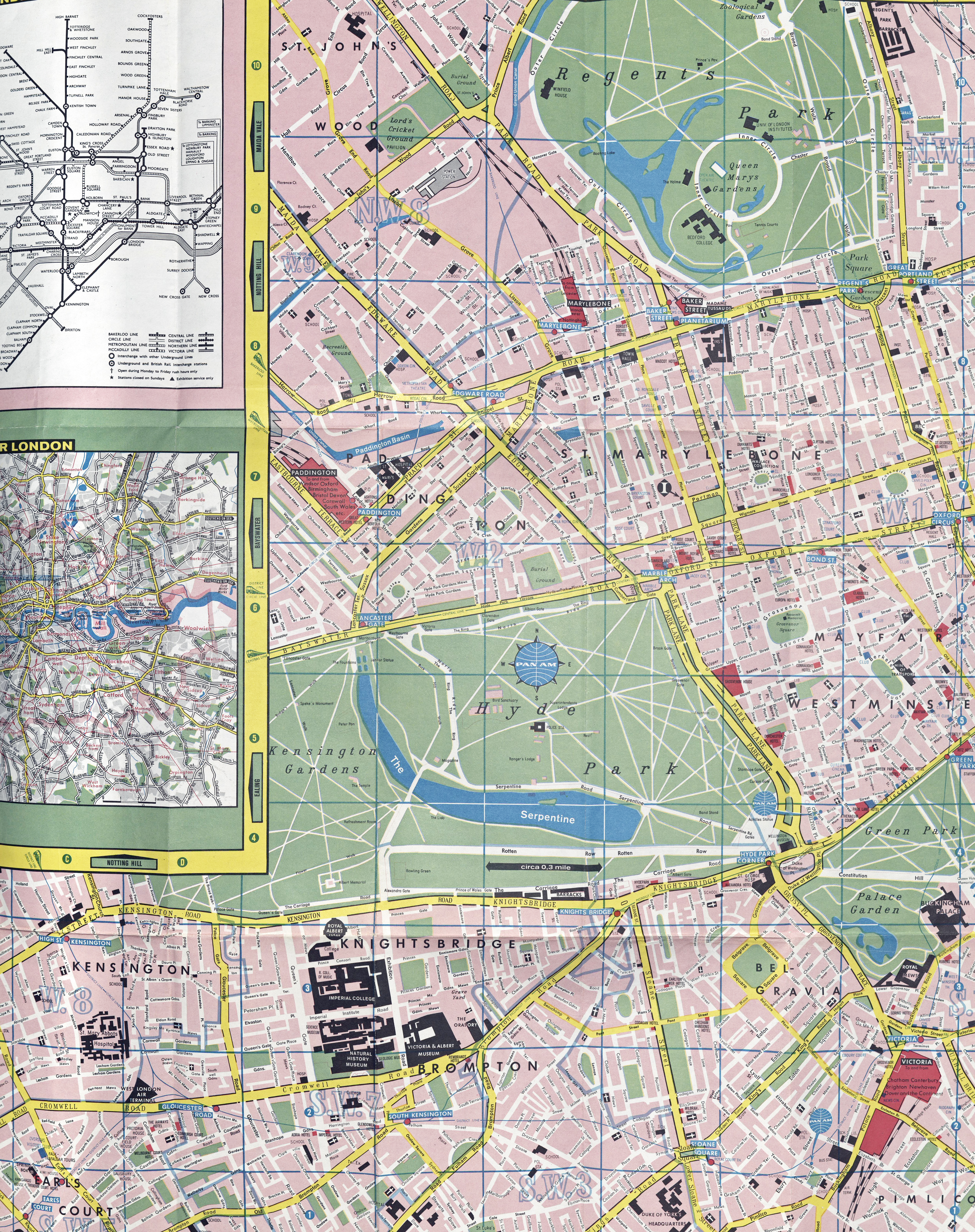
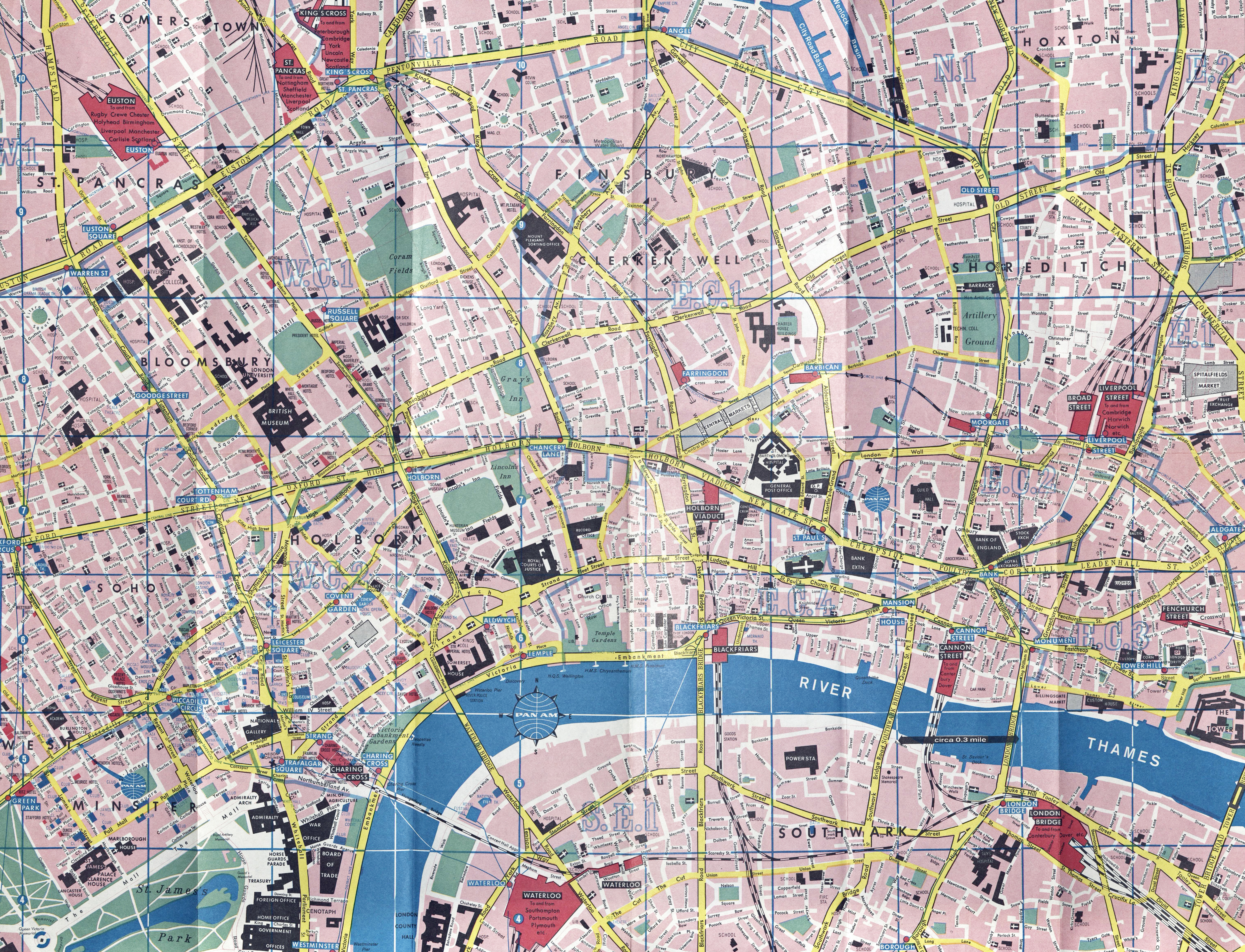
It is an excellent map, showing very good detail, roads and their names, one way streets are indicated, parks and their paths, major buildings, districts and postcode areas. A grid reference is included along with indexed streets on the reverse. The inclusion of an underground map drawn by Harry Beck is almost to be expected. The map was produced by Miniplans Ltd and is based upon Ordnance Survey mapping. It is a ‘Foldex’ map, a design invented by an Englishman in the 1930s. This folding system has each fold becoming progressively narrower. The free map must have been a greatly appreciated resource, especially when walking across London. One of the best maps shown here. With a legend in English, French and German, the small map was also amended, rebranded and provided by other airlines such as Quantas.
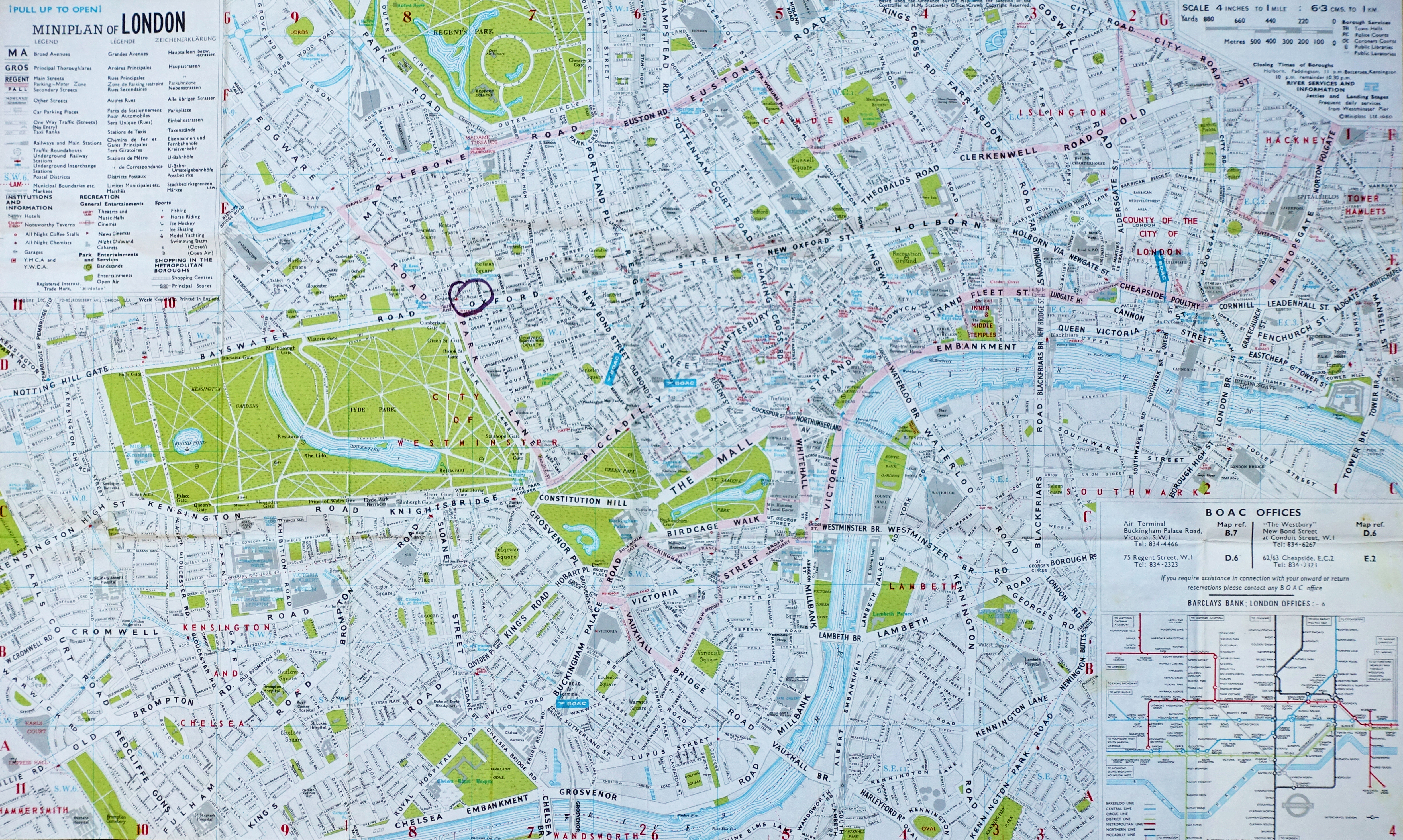
Detailed foldex map of London given free by BOAC. Produced by Miniplans Ltd and based on O.S. mapping. Scale- 4 inches to 1 mile (6.3cm to 1km). 1960
Heathrow Express
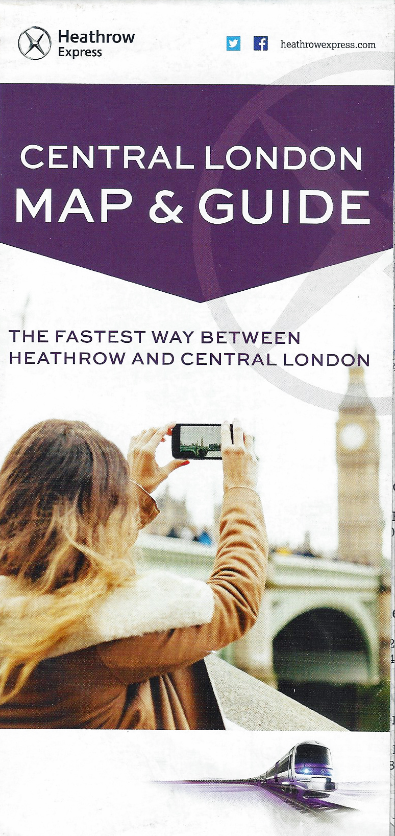
Central London map and guide produced by Heathrow Express and available to the public free of charge
Not to be outdone by the airlines, Heathrow Express, an airport rail link that operates between London Heathrow Airport and Paddington railway station has also offered London street maps to travellers in recent years.
The service has operated since 1998 however the map shown here dates from 2017. While it shows most streets to the south east of Paddington, few streets are actually named. One of its most useful features has not been included on any map so far shown, concentric rings give indications on walk distance for 12, 30 and 60 minutes. Heathrow Express ticket prices and a map of the TfL tube network, along with a minimum of information on tourist destinations is included on the reverse.
This map, for all its apparent detail, is almost impossible to use ‘on the ground’. Anonymous streets with no further detail result in a frustrating confusion if attempting to use it to navigate by foot through London. All gloss and no substance one might say.
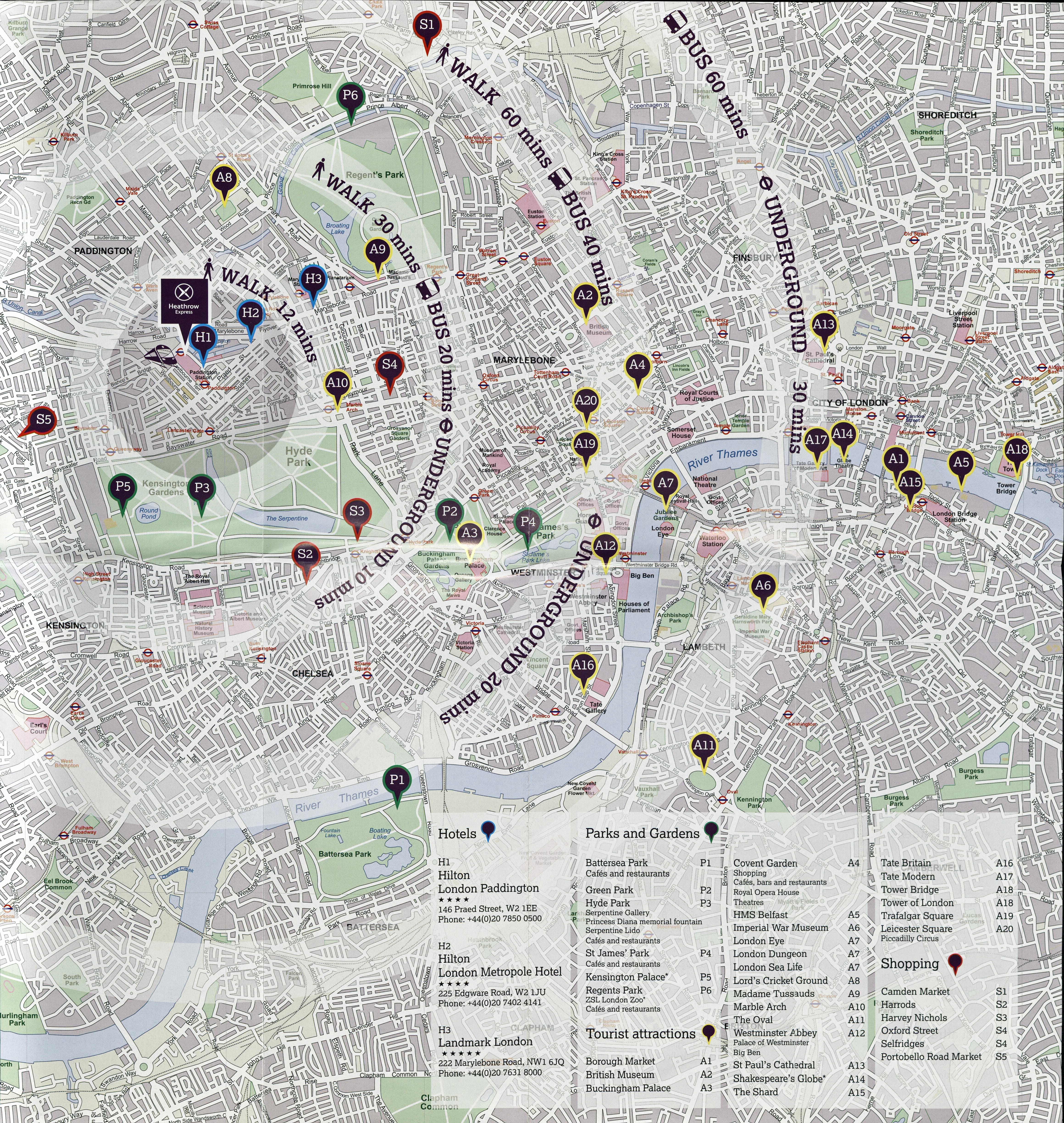
Map of Central London produced by Heathrow Express, 2017
Tourist maps
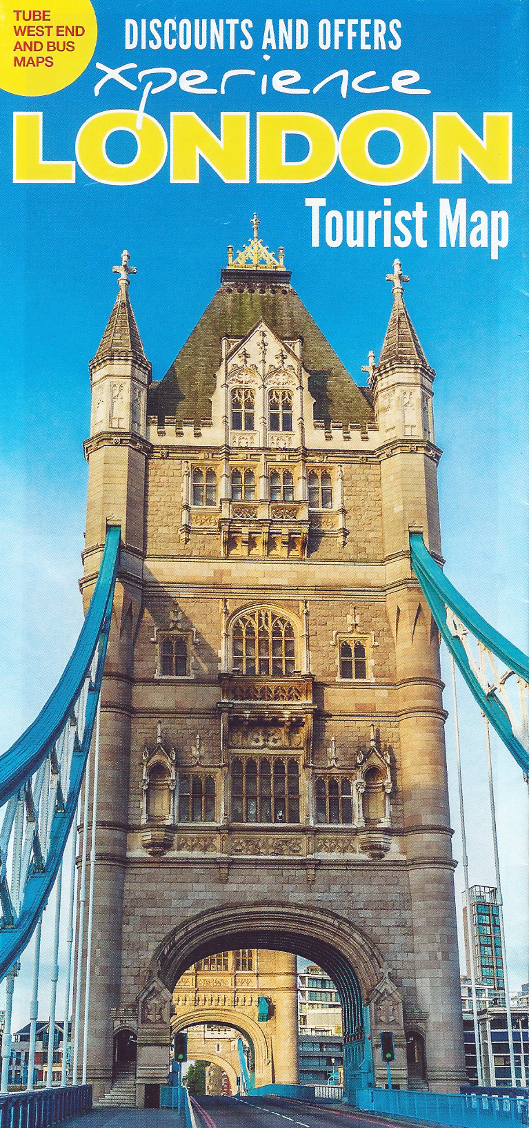
Experience London Tourist map, 2018
Every year, millions of tourists descend on London. The wide range of visitor attractions vie with each other to attract them. Other than actually having an attraction worth visiting, one of the simplest ways to achieve this is to become part of the ‘tourist trail’. Various bus companies provide hop-on-hop-off services around the capital, enabling the solo or family visitor to explore various destinations. For a price, a business could get their attraction added to the maps provided, free of charge, to tourists. These are also given out by street vendors, tourist information centres and other leaflet hubs.
Woe betide the place that is not included on the map, especially if they are located down one of the many un-named side streets depicted. The tourist dollar counts most with the production of these maps and competition and production subscribers are the over-riding factors in the map’s design.
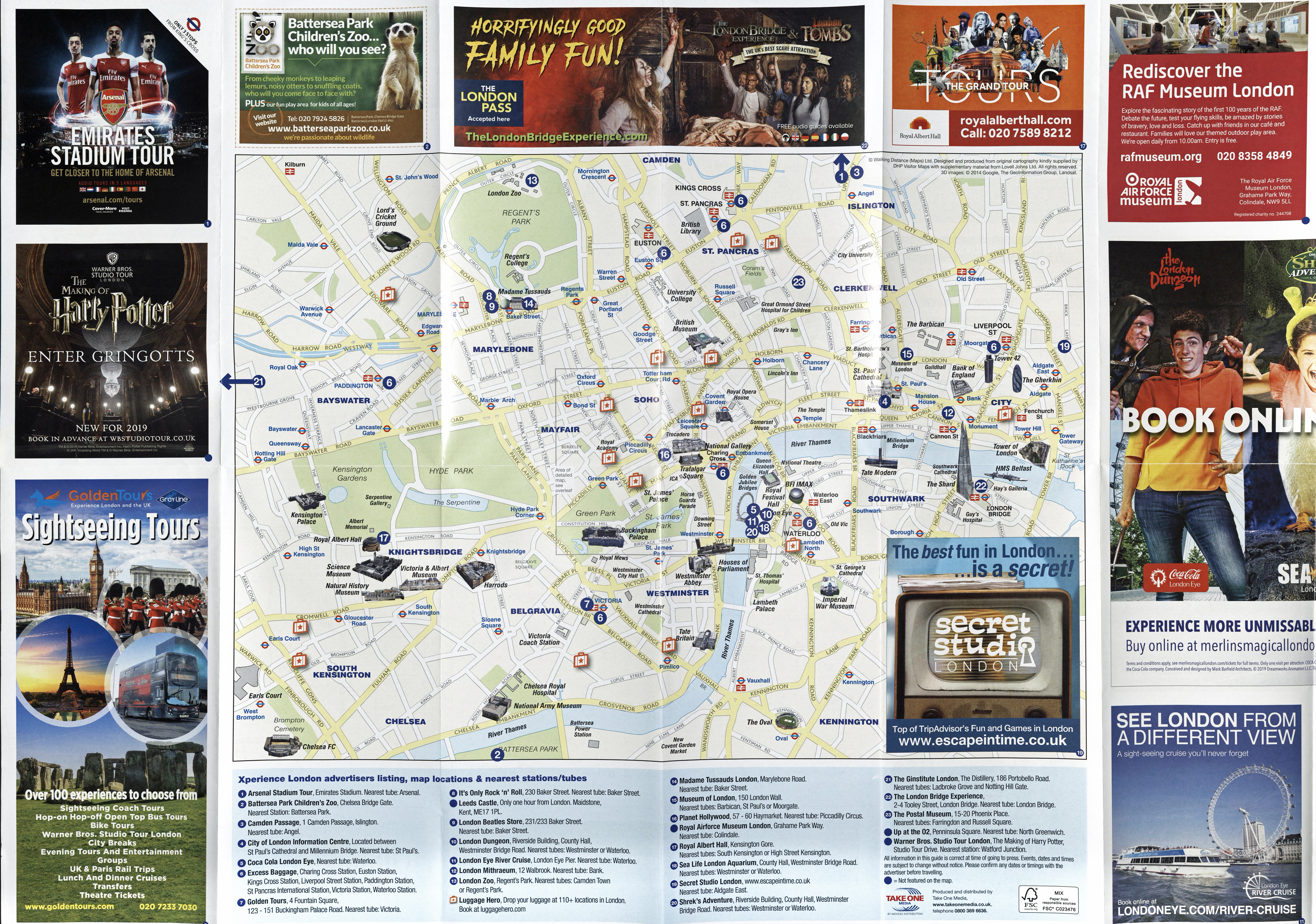
Experience London Tourist map. Freely distributed, the majority of the sheet is taken up with advertising various attractions with just about sufficient information on the map itself to enable tourists to travel between them. 2018
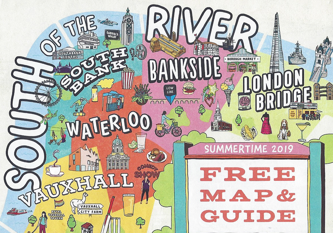
‘South of the River’ free map, 2019
Recognising this difficulty in attracting the tourist, some local councils in traditionally less visited parts of the Capital have backed production of free maps showing ‘their’ neck of the woods. Some designs of map have pushed at traditional design, again with the inherent problem of ending up with a product that looks pretty but is difficult to actually navigate with on the ground. Competing for the prize of worst map for walkers shown here, the South of the River map is a strong contender.
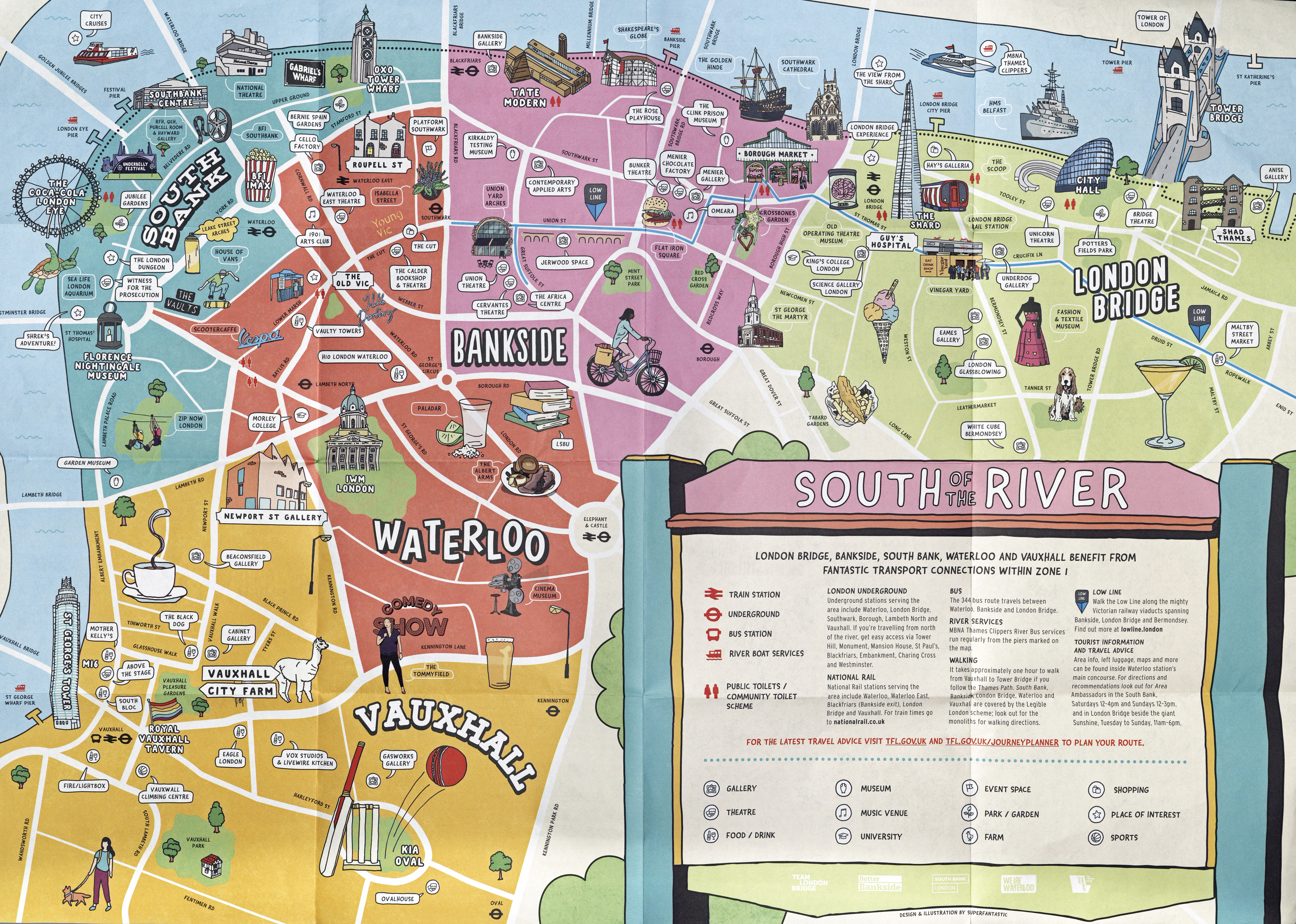
‘South of the River’ free map, 2019
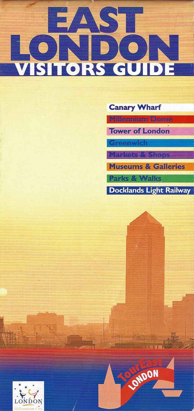
East London Visitors Guide, compiled 1998
The free East of London Visitors Guide compiled in 1998 is not much better than the South of the River map produced a decade later. On the surface it appears to be quite informative, containing information on transport, including boat services, accommodation and a plethora of tourist locations. However the map is woeful. Longer cross-London paths are indicated with dotted green lines however it would be impossible to follow any of these with this map alone, or find your way through the myriad of streets that have been left off the map. The map includes the Millennium Dome, not scheduled to open for another two years after the production of this map.
“here’s where the traditional East End meets the new city of London Docklands, where the World Heritage Site of Greenwich meets the wonder of the Millennium Dome”
Detail from East of London Visitors Guide. Try finding your way around Greenwich with this map and you would find it impossible without additional aid

London has possibly the greatest variety of history, architecture, culture, and social diversity to be found anywhere. Various maps have been produced that explore aspects of London though most have had a cover price. Today, online maps have made such a thing largely superfluous.
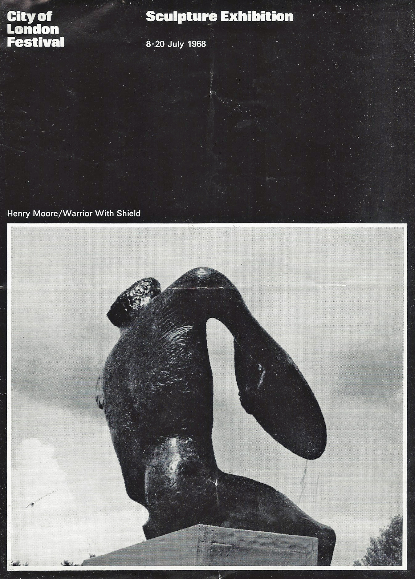
Cover to the 1968 Sculpture Trail in the City of London
As part of the City of London Festival, in 1968 a wide ranging selection of sculptures were exhibited. A map was produced to enable those interested to walk the streets and visit over a hundred works of art, though some were located in private residences, only open at specific times. One might view London as a huge sale room at the time as most of the sculptures were for sale.
Featuring Henry Moore’s ‘Warrior With Shield’ sculpture on it’s cover, the leaflet and map was published by the City of London Festival Committee and printed by The Ranelagh Press. It initially had a cover price of one shilling though this was eventually waived and it was made available for free.

Map showing the City of London sculpture exhibition, 1968

Mrs Three Points of the Compass sits beside the bronze statue of Paddington Bear at Paddington Station, London. This is the start point for the Pawprint Trail. Photographed en route to the Two Moors Way, 2012

Small leaflet with map produced by the Paddington Partnership for the Paddington Pawprint Trail in 2018. Just the right size for a child’s hands
If the above could be regarded as high-brow, then other sculpture trails in London have been much more fun. There have been Cow and Elephant parades and a giant Easter Egg hunt in 2011. A family favourite was the NSPCC and Visit London created Paddington Bear trail in 2014. Beginning at the bronze statue of the bear (erected in 2000) in Paddington Station, this trail sought out fifty Paddington Bear statues. The three foot six inch high “life-size” bears on the trail proved a firm favourite with children especially.
The trail was revamped in 2018 and an online and paper Pawprint Trail was published. A Tusk Rhino Trail was also created in 2018 but maps for this trail were available online only.
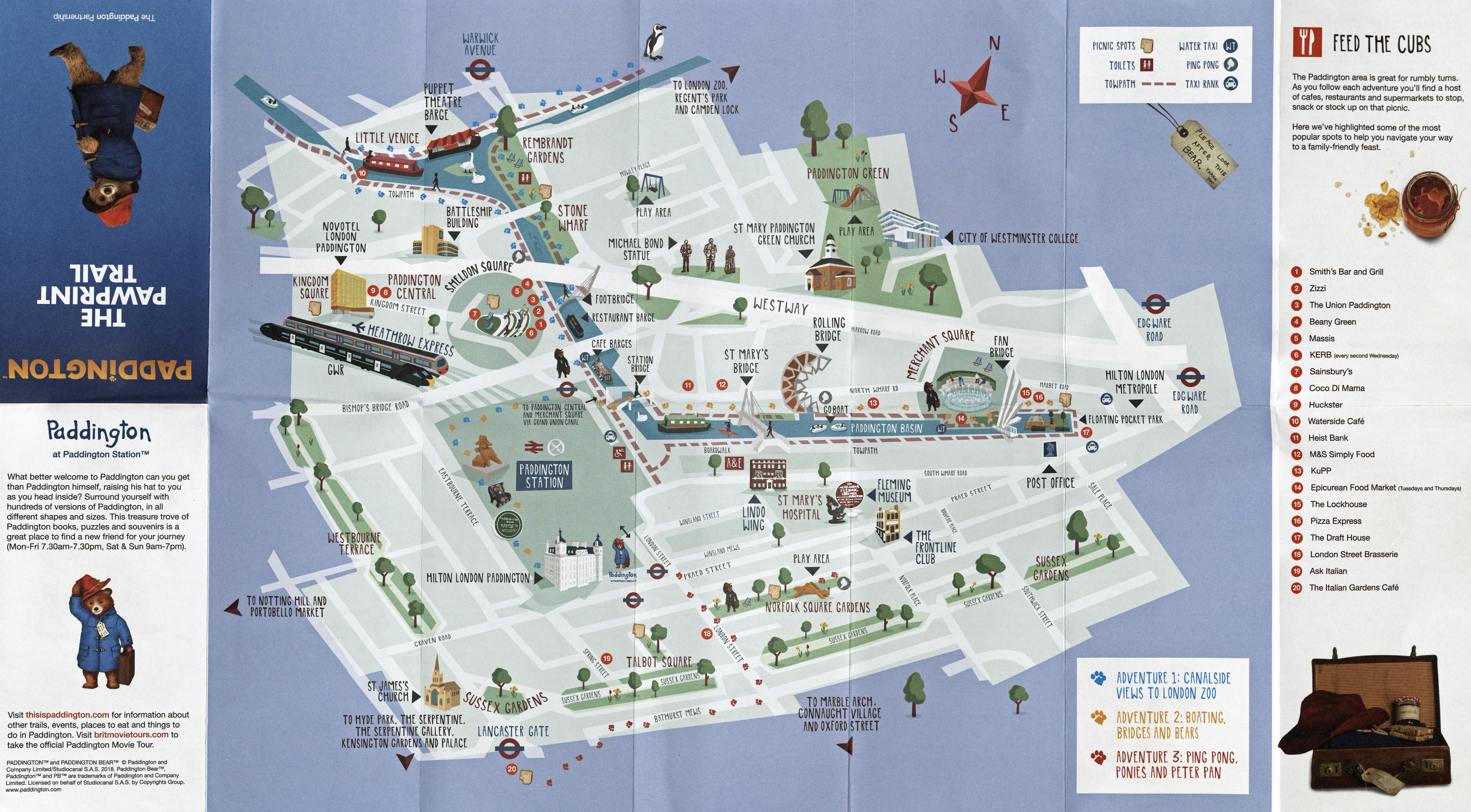
The simple map provided for the 2018 Pawprint Trail is barely adequate, but it is an undemanding walk with few opportunities to get lost so just about suffices. With a family audience in mind, the designer has included toilets, parks, play areas and picnic spots

Shaun in the City sculpture trail map, produced and issued free in 2015
Another popular walking trail was the 2015 route created for fifty fibreglass (a trade name for glass fibre) Shaun the Sheep statues erected across the City of London for ‘Shaun in the City‘. Based on the character from a stop-motion animated TV series, each large sculpture had been decorated by artists and celebrities. An accompanying book and paper trail map were produced. Proceeds went to support children in hospitals. The map was created from contributors to OpenStreetMap data. However actual street detail is woeful.
In common with many of the similar sculpture trails, they were subsequently repeated in other UK cities, together with maps, online assistance and participants were urged to contribute to the charities supported. No doubt we will continue to see many more of these fun sculpture trails. They are very popular. However it is the online provision of maps for these that appears to be the way forward.
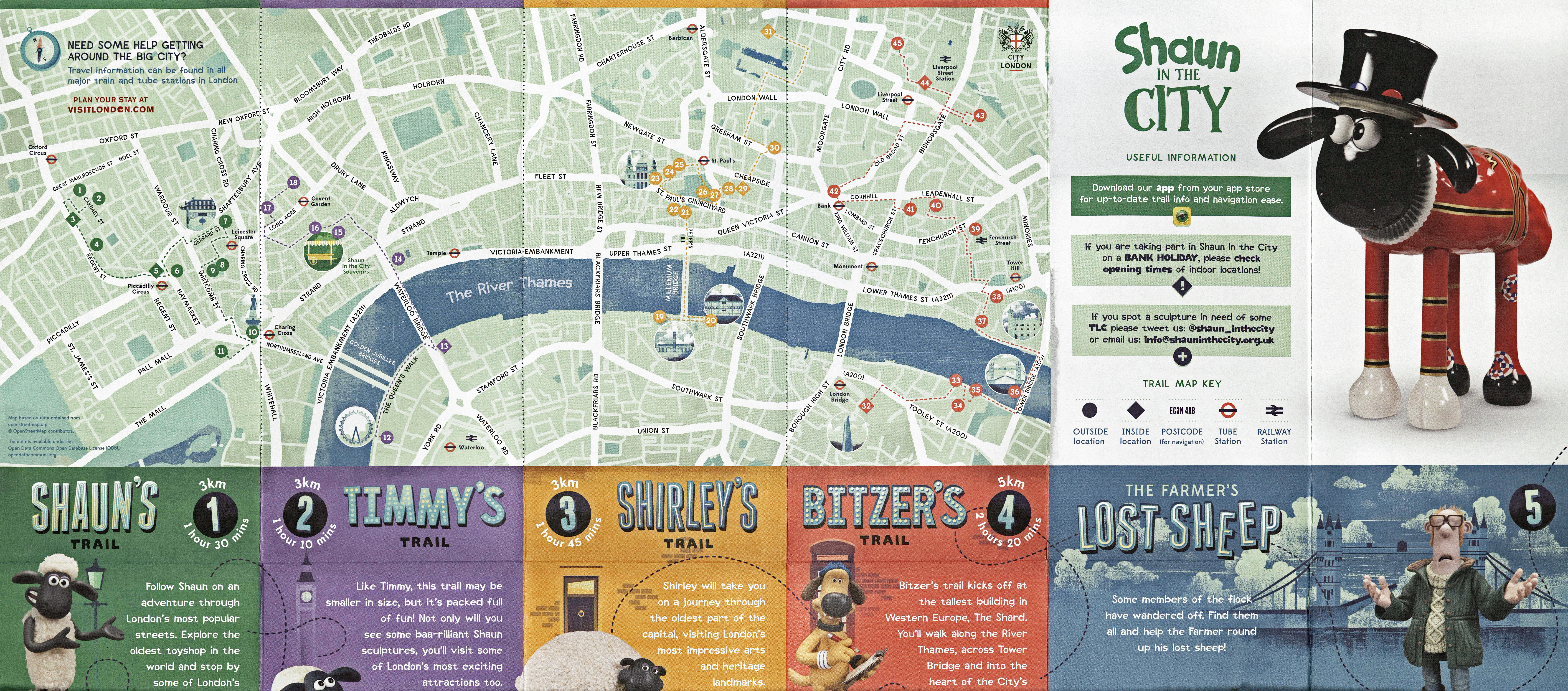
2015 map produced for families to track down the fifty Shaun the Sheep sculptures placed across London. Four different trails are shown, measuring 3km, 3km, 3km and 5km. Very little in the way of street names is included and Three Points of the Compass wonders how many people got lost without the assistance of the accompanying App
Brewers and pub owners
As mentioned previously, there are few reasons to give a reasonably accurate and expensive map to the general public free of charge. One straight forward commercial reason would be to encourage visitors to your establishments, be they theatres, restaurants, clubs or as shown here, public houses. But how do you get the public to visit more than one of your establishments? Perhaps in areas of London unknown to them or infrequently visited. By leaning heavily both on the unique features of your various venues and on the very history of London itself.
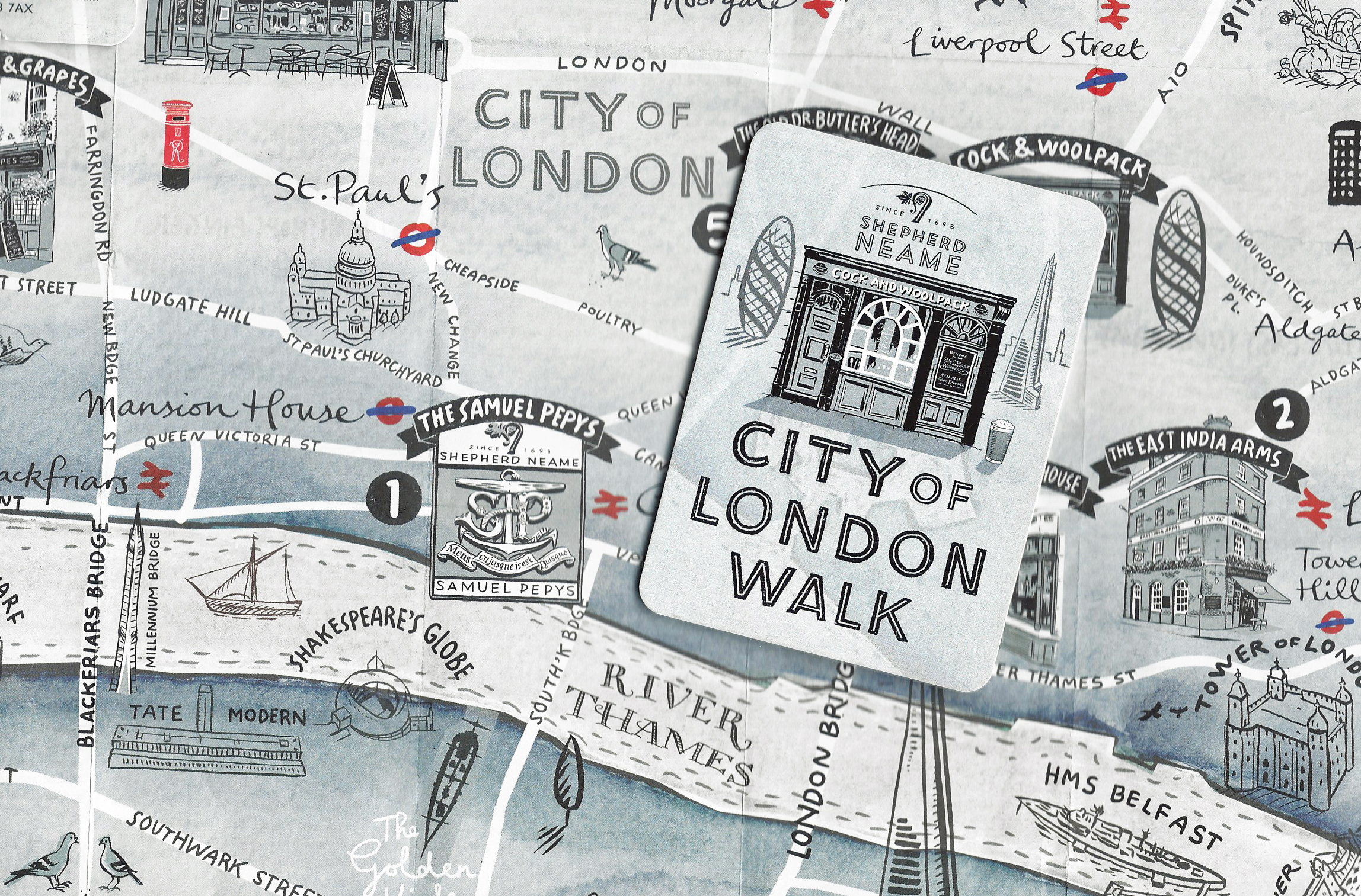
In March 2019 Kent brewers Shepherd Neame released a free map depicting a trail through London that visited eight of their pubs en route. Drawn by Peter Gander, it is an attractive product but not suited to actually following on the ground. Three Points of the Compass walked the route in November 2019
Three Points of the Compass walked one such route in November and covered the Shepherd Neame City of London Walk in a previous blog. While Shepherd Neame, who supplied the free map for that wander through London, relied most heavily on the history of their pubs, other brewers and pub owning companies have also incorporated history and mythology into their ‘pub trails’. The small Maidenhead brewer Nicholson’s was bought out in the 1950s and their brand is now used by Mitchells and Butlers for an enviable selection of historic pubs in London and other cities. A free map taking in many of the London pubs was developed and distributed free of charge to thirsty drinkers.
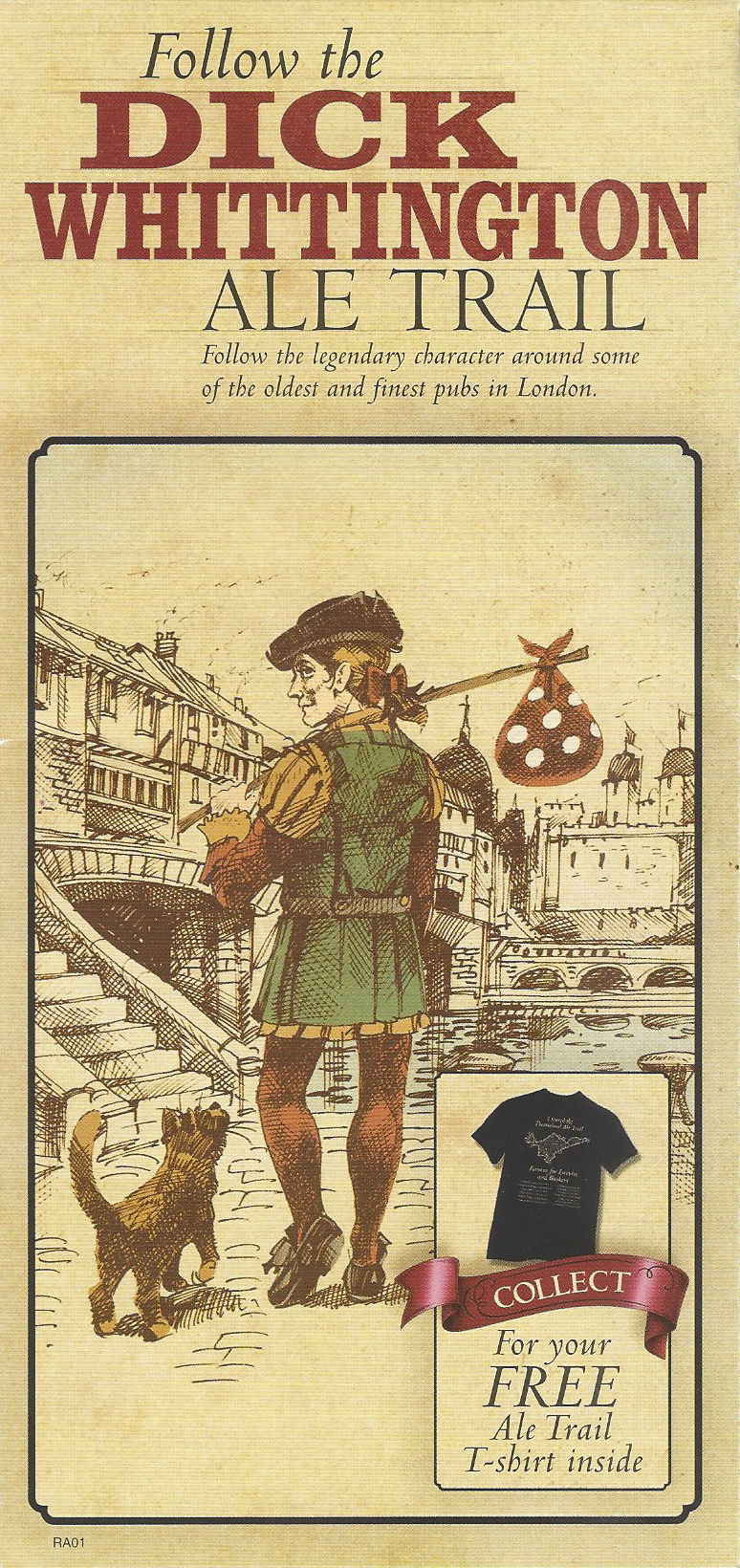
Dick Whittington Ale Trail, released 2006. Copyright Harper Collins
Nicholson’s London Ale Trail, 2012. Unknown map maker
The Dick Whittington Ale Trail produced in 2006 was aimed firmly at the tourist and expounded on the folklore story of his becoming Lord Mayor of London three times. The story could have been adopted by just about anyone however the excellent maps do provide six pretty goods trails taking in: Soho, Westminster to Piccadilly, Covent Garden, Blackfriars, London Bridge to Tower Bridge, and the Financial heartland.
So successful was this map and the extra turn-over created that it was rebranded as the Nicholson’s London Ale Trail and repeated, with a different map and tweaked trails, in 2012. Presumably it was felt that the original map had pushed the brand insufficiently as the 2012 version carries more detail on the company’s pubs, their food and beers and which Nicholson’s pubs could be found in close vicinity to London.
One side of the Nicholson’s pub trail released in 2006. This shows three trails taking in seventeen pubs on both sides of the River Thames
Second side of the Dick Whittington Ale Trail. While this does take in 29 pubs across the three trails shown, the attractive map also provides lots of accurate street detail for those simply exploring and is amongst the best of free maps ever produced for London walkers
The Nicholson’s Ale Trail map produced in 2012 demonstrates a total refocus from their earlier offering. This map concentrates on the pubs and provides far less detail of London’s streets and parks. Compare how little detail in Green Park is depicted against that on the earlier Dick Whittington Ale Trail map.
I have shown just one side of the 2012 offering from Mitchells and Butlers here as it is a much poorer map. The pedestrian is completely abandoned in some parts of the City. To the east of the Thames, the area around Waterloo station has been largely ignored in favour of advertising of venue hire.
City of London Visitor Trail
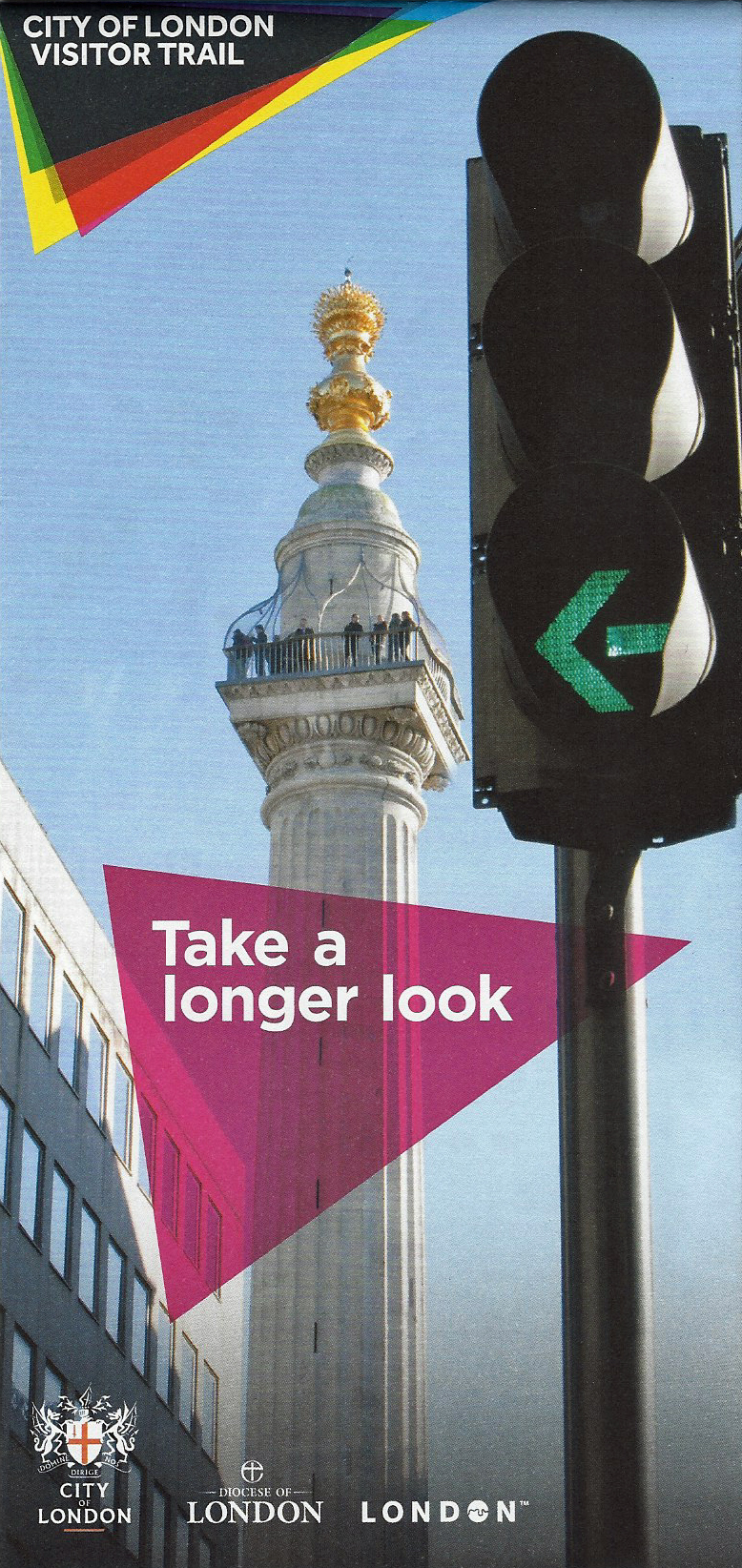
Map of the City of London Visitor Trail. A joint initiative between The City of London Corporation and the Diocese of London. Printed September 2016
Demonstrating that there is still a demand for paper maps for walkers, alongside suggested routes and things to see in London, a City of London Visitor Trail was quietly launched in April 2013. Having ironed out the kinks a marketing campaign kicked in August 2014. Over 130 thousand maps were distributed showing tourist routes that walkers could follow through the City of London.
Six themed routes: The trails, Law and Literature, London Stories, London People, Culture vultures, Skyscrapers ad sculpture, and Market mile enable people to experience much of the best on offer. The trail received funding from Tower Bridge, The Monument and Guildhall Art Gallery, it was sponsored initially by The Diocese of London. Needless to say an app, map and supporting information was made available online.
It is refreshing that it was still thought practical to include a physical map. Not only that, but a well planned, clear and informative one at that. It may have lacked some distinctive flair but was efficient if impersonal. More recently the trail branding has become more ‘child friendly’ but the opportunity remains for those merely curious to indulge in independent wandering of the streets of London.

City of London Visitor Trail is adequate for visiting many of London’s tourist spots by foot. Each square represents approximately 400m, taking roughly five minutes to walk. Printed September 2016
Canals
It is not just streets and their accompanying paths that cross London. The Grand Union Canal System, known as “London’s Canal” crosses from the west through built up north and east London to join the Lea Navigation via the Hertford Union and Limehouse Cut in the east. Anyone choosing to can follow over 40 miles (64km) of towpath across London.
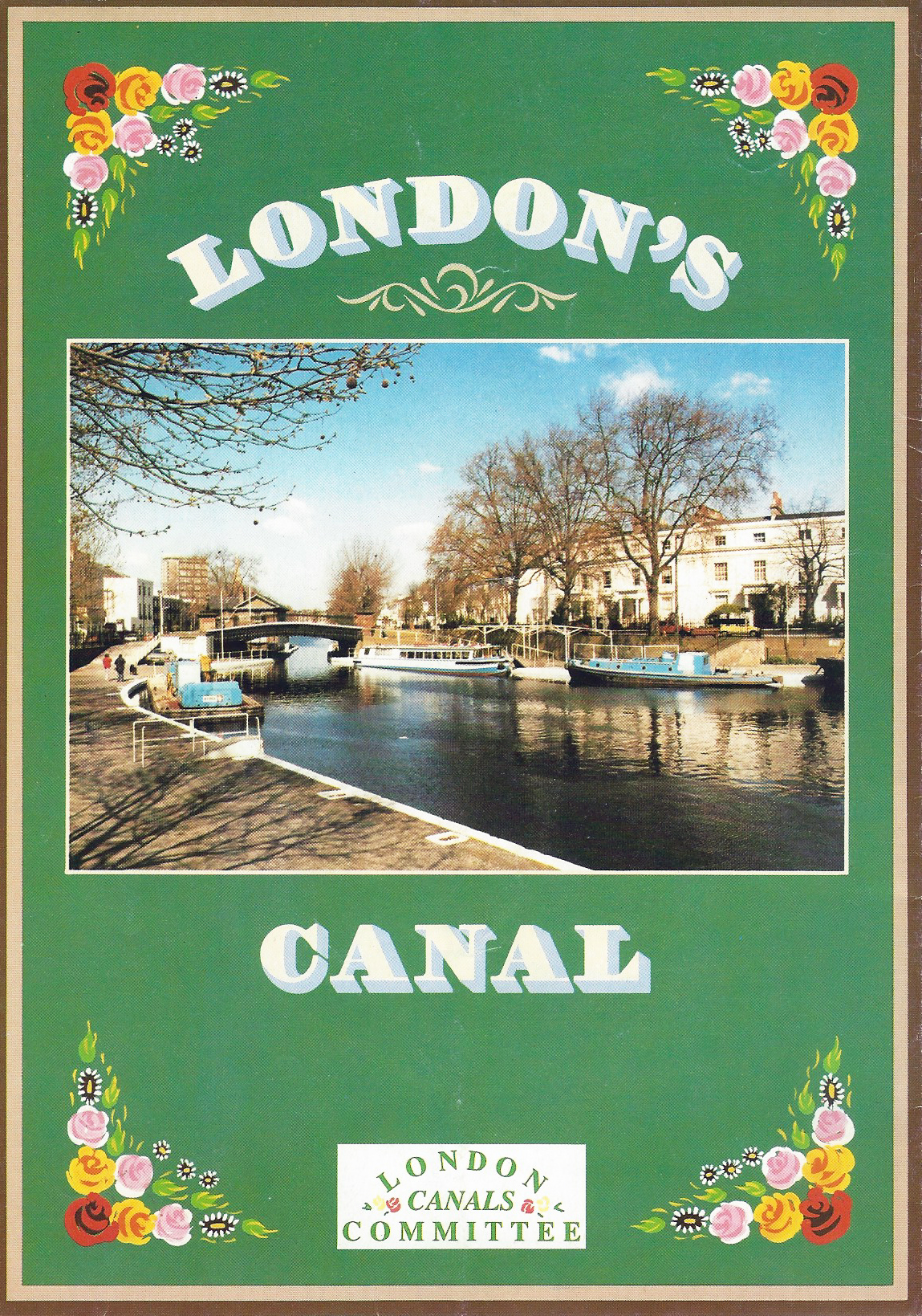
Free London canals leaflet, Produced and printed by the London Canals Committee, 1988
While there are dedicated canal maps and canals also appear on well produced maps such as those by the Ordnance Survey, those maps cost money. Some stretches of canal have also appeared on simple free sheets showing short walks on parts of the system.
There has been little produced, free of charge, that shows all of the system that can be walked. The closest has been the very simple diagrammatic map leaflets produced and available for free from the London Canals Committee. This group was formed in 1966 as the London Canals Consultative Committee as a co-coordinator for canal matters. The map shown here, produced in July 1988 almost ignores any of London away from the canal itself. Following the map, the pedestrian would struggle to know where they were in relation to the wider city. But it would, just, be possible to cross London with such a map.
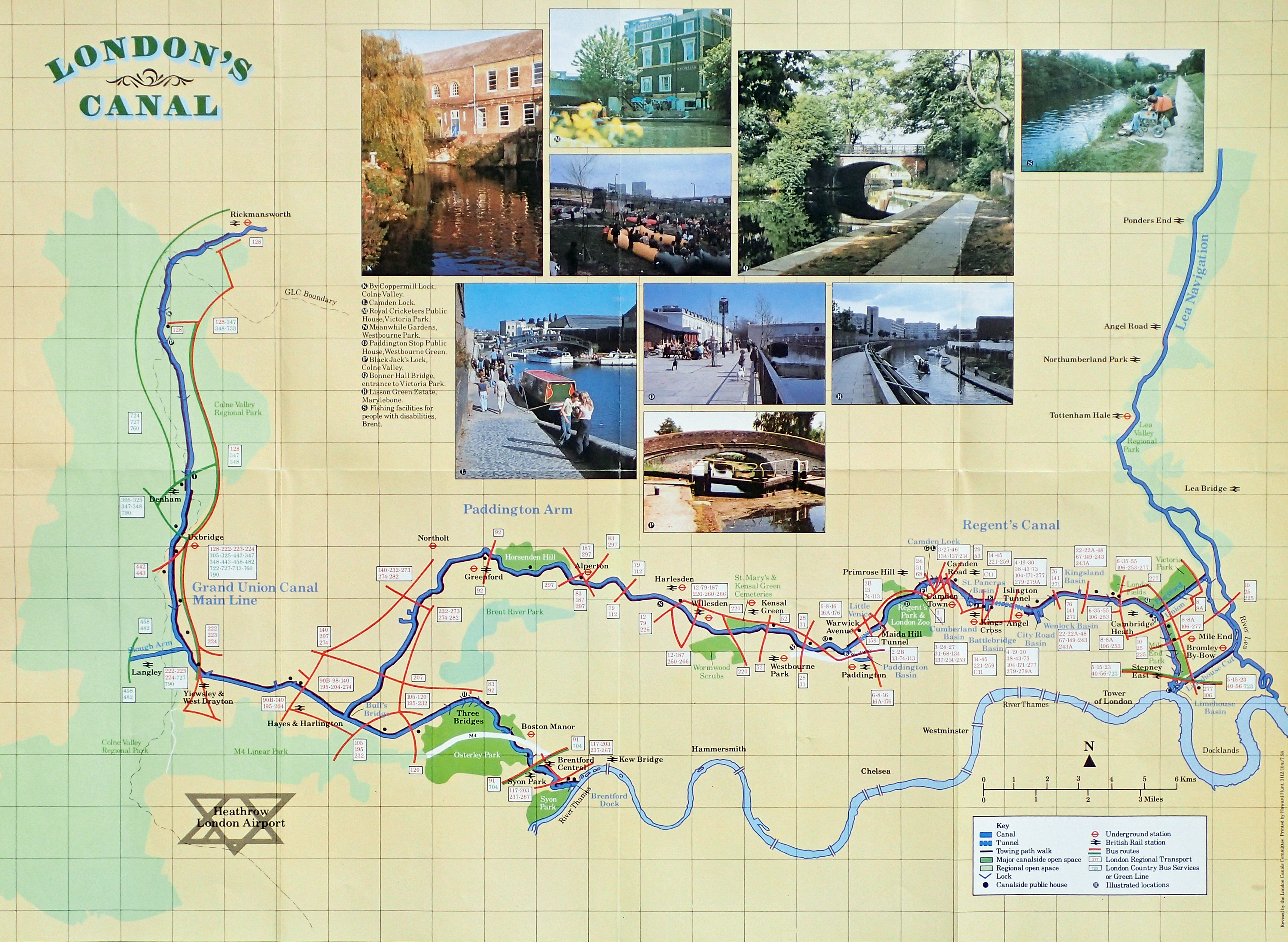
Revised canal map produced by the London Canals Committee and printed July 1988
A huge number of free maps to aid a visitor in walking around London were produced as part of the 2012 Olympics
This brief glance at some of the free paper maps available to London pedestrians has omitted a large group of material and a couple of themes in particular. Three Points of the Compass will take a closer look at these in the final three parts of this short series- the plethora of material released by Transport for London, also those produced in association with the 2012 London Olympics.
To end with, later in the year, we shall take a glance at the commemorative maps produced free for the public in connection with some of the Royal events in London.

Fascinating article. Are you aware of the map service provided by the National Library of Scotland?
LikeLike
No, tell us more…
LikeLike
Take a look here , https://maps.nls.uk/
Fascinating site to get lost in.
Derek
LikeLike
Thanks for the link Derek. I agree, very easy to get lost in the rabbit hole of online map resources. I deliberately tried to exclude the fascinating and wide range of digital resources out there. Many of which can take a bit of tracking down. Your suggested portal is an excellent route in to Bartholomew and O.S. London maps and other.
I am also especially keen on Booth’s Poverty map and the London Tree map, it really is amazing what there is to be found on the web
LikeLiked by 1 person
I have found the BOAC miniplan in my father’s house – amazing
LikeLiked by 1 person
One of the better freebies Kim
LikeLike