
Three Points of the Compass walked Scotland’s Skye Trail over six days in May. The first two days were wet and windy. But would I get blown off the Trotternish Ridge?

I drove to the Isle of Skye from my home in South East England. I made it a two-day journey as I wanted to stop at the Lake District en route. More on the reason for that particular halt in a future post. By the time I was driving over the bridge to Skye from mainland Scotland the weather had set in and the rain was hammering down. I tried Broadford first. The camp site was full, as were the three hostels. I did chat to some hikers at the bus stop. The first looked downbeat and weary. I asked what the trail had been like. His eyes had a haunted look about them and he muttered his assessment- “tough”. Two couples had abandoned the trail, I asked why and found out their tents had been wrecked by the winds. Just what had I committed myself to!
At this point I had no wish to go searching out a B&B so drove on to Portree where I had pre-booked a pitch at the campsite up the hill out of town there, just in case. Just as well as the weather had driven people into accommodation and on to campsites across the island and they were no longer accepting walk-ins at Portree. I had also arranged to leave my car at the camp site, for a cost. Once the tent was up in a decently protected corner of the quite large site, I decided as the walk hadn’t actually started yet I wasn’t officially a pedestrian so drove the mile back down the hill in to Portree to queue in the driving rain for fish and chips. Taking them back to the camp site to sit and eat them in the car. It was a sodden and miserable evening and I wondered just what it was going to be like the following morning. It was forecast to rain overnight then slowly dry up for a couple of days.
I was wrapped in my quilt in my tent by eight-thirty in the evening, rain hammering down on the Durston and wind rattling the fly. It was all fine though and I would have contentedly drifted off if it were not for the loud talking, occasional shouting, and rattling of pans from the small group of campers who had decided to pitch just feet away. It eventually became quiet and when I briefly stirred in the small hours the rain had stopped.
Day one: Rubha Hunish to Flodigarry
I rose at 6.30 for a brew, drunk while I packed up and I walked down the hill in to Portree in plenty of time for the bus. There was conflicting information about my transport. I knew it was bus 57C, but the website is hopeless, with 9.05, 9.10 and 9.15 being given as start times on the various timetables found. More worryingly, two different squares in the town were given as the start point. I had time to spare and went to MacKenzies Bakery for a couple of decent bacon rolls and mug of tea, sitting at the bench outside which was a decent vantage point to observe the comings and goings at the bus stops at the adjacent square.
A couple of minutes after nine one of the buses at the Portree Square bus terminal switched its indicator board to 57C and the small congregation of anxious hikers and indifferent locals boarded and paid. We were off. Three minutes later we halted at the bus stop at the entrance to the camp site to take on two more hikers!

The “red phone box” is the start point for the Skye Trail. Every hiker boarding the bus asked the driver for it and it is a very obviously familiar point of reference.

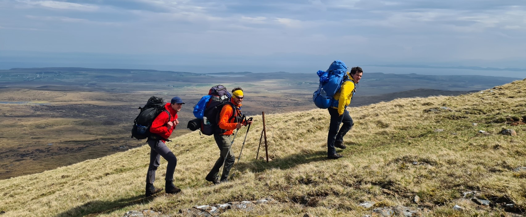
Disgorged from the bus, there was a thin mist and light rain as the small collection of hikers gathered at the roadside. Packs off, waterproofs on, packs on, photos, quick introductions, ones and twos gradually left to climb the track and head off up the couple of miles toward the Rubha Hunish point of the peninsula, home to the old crofting clachan of Erisco, the most northerly tip of the Isle of Skye. I was both eager to be starting but also conscious that today was a short and probably the trails easiest section of just 7.5 miles, though admittedly the terrain slows progress considerably. A large fold of Highland Cattle and their sweet little calves was passed. These placid creatures were obviously familiar with a steady stream of walkers but mums and their charges always need to be given a degree of respect and care should be taken not to pass between the two. Respect seemed to be an alien concept to a group of youths walking back from the lookout point to the road. Standing close to the cows and bellowing at them seemed to amuse them. The group of seven had spent the night in the nearby bothy and I was thankful I hadn’t had to endure their presence. Further on I met US hiker Mary Jo Amani, inordinately happy to be completing the trail, slackpacking her final day as a loop out from the Flodigarry hostel. We briefly chatted but we each had miles to complete, so with a promise to meet for a drink and natter later we parted. It was then up to The Lookout, a former coastguard lookout perched on top of 117m vertical basaltic columnar cliffs, overlooking the Little Minch, an important shipping channel though not a great deal could be seen this morning. I stopped in at the little building, now a bothy maintained by the MBA but had no need to stay for any length of time and left a hiking couple, Mark from the UK and Marter from Canada, pausing there for a second breakfast. They were both far stronger hikers than me but we saw each other frequently over the next five days until I finally leap-frogged way past them when they stopped for an earlier finish to the day than I.


The rain occasionally blew across the peninsular. I packed the phone away for most of the short hike that followed and paid attention to where I was walking. I passed a couple of hikers. I had seen them on the bus earlier. One was wearing cream coloured trousers and I had thought then that they wouldn’t stay pristinely clean for long in this peaty environment. He was already mud bedaubed and belatedly putting waterproof over trousers on. The ground was boggy, slippery in places and already required a little care in navigating. I heard later that he had badly turned an ankle on this first day and his hike was sadly over.


My trail kept to the seaward side of rough crofting land. There are some dramatic drops off the cliffs along this section and on a rain soaked day, I was careful not to come a cropper, wading with impunity across one burn, no river crossing footwear for me, and the path eventually descended to the shore. It was only a short walk from there round to Flodigarry and before I had really got my teeth in to my first day on trail, it was over. The weather now brightened up dramatically, typical! I went up to the hostel. All locked up. A couple of people came and went but refused to let me in. There were strict instructions in place that new arrivals were not permitted to enter until 17.00. Anabelle runs a tight ship, turfing out people in the lounge or kitchen area if she discovers them, regardless of the weather. Mary Jo had put up her tent for shelter when she arrived here the day before as the rain was chucking it down and there is no shelter here otherwise. I had walked past her tent on the drying line on the walk in. With hours to spare until I could check in, I made the short walk to the hotel next door, peeking at Flora MacDonald’s cottage in it’s grounds as I did so. This is now an expensive holiday let.

The hotel is an upmarket and expensive place, far too pricey for me to eat there but I decided I could splash out on a couple of beers and sit on their sheltered veranda in the now warm sun, though there was a cold wind blowing. I was joined by a small group of day walkers, then Mary Jo, then another trail walker, who stopped just long enough to briefly chat and rehydrate before he continued on to the next section. He was hoping that he could camp low as the distant Trotternish Ridge was cloaked by cloud and conditions were no doubt a bit rough up there. I had already decided that I was halting at the hostel and had booked a bed in a six person dorm weeks before. I had also pre-ordered half a loaf of bread, butter, a couple of tins of beans and some eggs. My evening meal and breakfast therefore comprised beans on toast. With fried eggs today, poached tomorrow.


Day two: Flodigarry to the Storr
After yesterday’s simpler leg stretch, I knew I had a big day today. The Trotternish Ridge is a dramatic one or two day’s hike and easily the most challenging section on the entire trail. The 1750m of ascent over some 17 miles is deceptive. The terrain is exposed, often difficult, steep, and perhaps surprisingly for this walk along the escarpment, the trail is frequently unclear on the ground, requiring careful navigation. It is a section not to be taken lightly and requires planning and experience. I had already decided if the weather was poor I wouldn’t go up there but wait for it to improve, but instead my day dawned bright and sunny. However I was aware of the usual forecast in these parts- if it isn’t raining, its going to. I didn’t want to camp midway along the ridge as there is little protection from the elements, so it had to be completed.
The start to day two eased me gently into this section. Leaving the hostel, it was a short march along the road before turning off and beginning the initially gentle ascent to the base of the Quiraing, passing two small lochs on the way. Perfect wildcamping for those not wanting to stop at Flodigarry.


It is a good path, and having gained height, branches left, with the Quiraing towering overhead on my right. This is lovely walking and I wished it were longer but all too soon the path began the long descent to the Uig-Staffin road where there is a large car park. More importantly, along with the many dozens of cars and motorhomes disgorging day walkers and tourists, there was a decent mobile snack wagon. Conscious of the exertions to come, I made time for a large tea and a couple of decent bacon rolls. That set me up for the steady climb up to the summit of Bioda Buidhe. I chatted to a trio of German scouts (presumably Rover Scouts that have an upper age limit of 20) that powered past me. They were the hares and I was the tortoise and we leap-frogged each other throughout the day as they seemed to like long halts while I just plodded on, with briefer snack breaks or for breathers and for glugs of water.

The walking was fantastic, so was the wind, that increased in strength as the day drew on until it was a struggle to remain upright. I saw two Golden Eagles over the lip of the escarpment below me, looking like a pair of barn doors had been carried aloft by the wind. The only thing I can put in the wind’s favour is that it dried up the mud a bit on some paths, not that there were many actual paths and I still squelched my way through the soaking grassy morass for the best part. I stopped and sat on a rock for a quick lunch that comprised a pepperoni, flat bread with squeezy cheese and a couple of handfuls of mixed nuts. The Germans passed me yet again. Further on it was my turn to pass them while they were filtering water.
The going was frequently slow. I’m a solo hiker and take a good deal of care as there is little in the way of escape routes here in the event of injury. The Scots have a word for the going underfoot, especially applicable for what I encountered while carefully negotiating my way down many of the awkward descents- ‘slaistery‘, meaning muddy and slimy. This was affirmed when my feet went from beneath me on one particularly steep drop. Nothing dramatic, I simply sat down heavily, unfortunately with one pole beneath me. I sought out a fence post further on to act as a fulcrum and pull the banana shaped lower section back into something almost straight. These were my tent supports as well and another reason for not using carbon fibre poles, which will splinter and shatter rather than bend like aluminium.


Some reports advise the hiker to carry all the water required for the entire day, and for a nights wildcamp, saying there is none to be found. But there is water up on this ridge, leaking out of the sodden slopes into driblets that would swallow a foot, leg or more if you plummeted into them, unnoticed in the tussocky grass, rather than simply stepping over. I filtered as I needed to, using my Pure Clear filter. I suppose these mini-burns might dry up later in the year, but for now, in May, there was plenty of water. If need be, you could search the western slopes, descending from the bealachs, to the burns further down that run all year round, but that would mean a long climb back up.
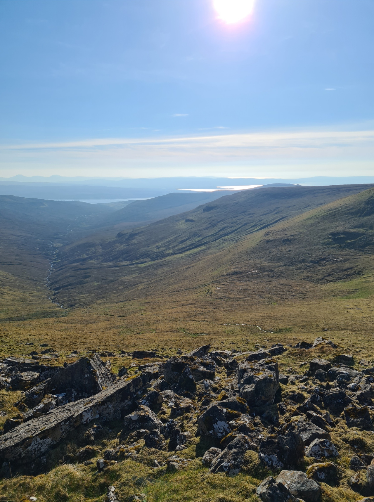
There are a number of summits to be crossed along the ridge, many steep, both approaching and leaving them. I forget how many climbs, at least eight I think. My progress was frequently painfully slow. I cared not. The view from the tops to the coasts, on both sides of Skye, are both expansive and terrific. And in front of me, to the south, the brooding Cuillins could be seen.


By the time I descended Hartaval and slowly, ever so slowly, climbed out of Bealach a’ Chuirn toward the Storr I had had enough. I had been on trail for over 12 hours and began looking for somewhere sheltered. I was fortunate there was a decent outcrop of rock behind the Storr and headed toward it, finding two small tents already pitched with occupants inside. No problem though, there was plenty of room to move along another fifty metres and still pitch with decent shelter from the still strong wind. I ran out a couple of extra guys and used every peg I had, double pegging a couple of corners in case the wind swung round during the night. I had a decent view back to the ridge I had just completed, the sun sinking toward it, but had no energy to sit and take it in. I knew the light would be fading and I wanted to get a bit of a tent wash, and get a brew and meal inside me. By the time that was completed it was just about dark.

I ventured out of the Durston for a last pee and then settled down for as much recuperative sleep as I could muster. Not stirring again until the following morning. It had been a good day and I was quietly pleased with my progress. Today’s walk on the Skye Trail had been an absolute pleasure, demanding that it was. I had another four or five days hike still to come but for now, the most difficult section was behind me.

Thank you for taking us along on your adventure . I wondered what it looked like there and what it was like , you have a gift of excellent description .
LikeLiked by 1 person
Nice of you to say! My apologies, but a bit of a wait for my post on the remainder of the Skye Trail. I have a series of daily blogs from the trail being started tomorrow morning first…
LikeLiked by 1 person